Chapter 2: Water Resources
Overview
Watersheds and Rivers
Ogunquit River and Watershed
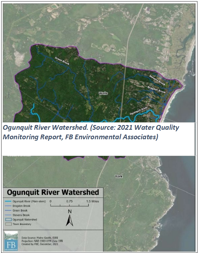
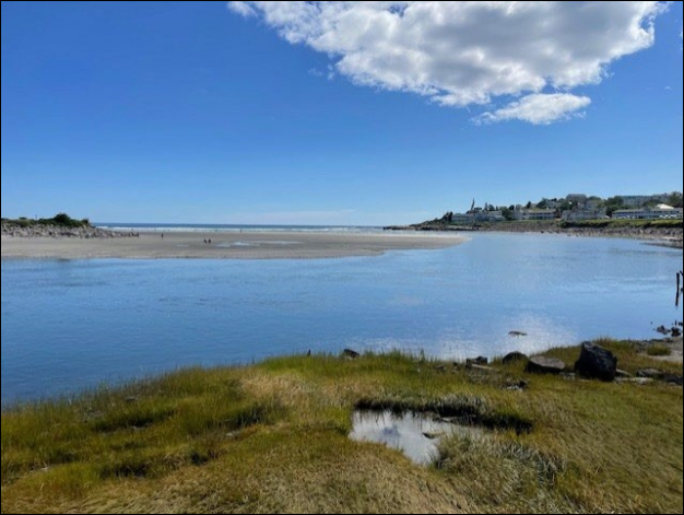
The Ogunquit River begins with the joining of two small streams just south of Bennett Lot Road in the woodlands surrounding Mount Agamenticus in South Berwick. Traveling east, it crosses under Old County Road in South Berwick, continuing to flow through forested lands and an occasional field. A mile further it is joined by two brooks draining the Third Hill area of York and then turns north passing under the Ogunquit Road. It then converges with Tatnic Brook, before flowing east and meeting up with Green Brook; both brooks are major tributaries draining the largely forested Tatnic Hills in the Town of Wells. Continuing east, the river encounters an increasingly developed landscape as it crosses under North Village Road, then Captain Thomas Road, and under the Maine Turnpike/Interstate-95 toward Route 1, all in Ogunquit. Shortly after passing under Route 1, the river cascades as a waterfall to the head of tide and an expanse of a salt marsh and estuary. Water flow is then amplified by the tides, Stevens Brook, and the salt marshes to the north before bending south for a mile behind Ogunquit’s barrier beach. Leavitt Stream, a small tributary, enters the river near its mouth, just upstream of the Beach Street bridge. The
river widens considerably then meets the rocky bluff of Israel Head, taking a sharp turn and emptying into the Gulf of Maine at an outlet on the south end of Ogunquit Beach.
The Ogunquit River and its tributaries combine to form the Ogunquit River Watershed (Map 1). The Watershed covers an area of approximately 13,300 acres, or 21 square miles, and spans portions of the towns of Wells, Ogunquit, South Berwick, and York. Approximately 17% of the Watershed is within the Town of Ogunquit. The outer boundary of the Watershed starts in the Tatnic Hills in Wells and South Berwick and continues south to Third Hill in York at an elevation of approximately 250 feet above sea level. The Maine Turnpike/Interstate-95 runs north-south through the Watershed, with the majority of development, including dense pockets of businesses and residences located along the Route 1 corridor, which is east of the Turnpike. To the west, the Watershed land
consists primarily of large blocks of undeveloped land and scattered residential properties. All water (precipitation, septic, and irrigation) within the area either evaporates, is absorbed by plants, or eventually migrates into the river and flows to the Gulf of Maine. Due to the relatively small size of the drainage area and predominantly shallow soils over bedrock, river flow rates decrease in dry periods and have even ceased during summer droughts.
There are no remaining man-made dams or flow restrictions on the Ogunquit River. A few active farms remain and at least one has used the river as a source of irrigation water. The Ogunquit River Watershed provides for recreation opportunities, scenic views, and wildlife. It includes a 2- mile barrier beach which, together with the river, serves as the primary attraction for thousands of seasonal visitors and supports a vigorous and increasingly year-round economic base in
Josias River and Watershed
Water Quality Monitoring and Management
- Lowerparking lot catch basin
- TownLyne Motel catch-basin, and
- Three R-Tank catch basins at Maine BeachParking Lot, where an existing design directs all outflow from the parking lot areas and properties to Riverside
- Soil,sand, and sediment carried by wind and water from disturbed land including construction and
- Salt from snow plowing, which is neither treatable nor able to be removed with
- Chemicals from pesticides, lawn care, vehicle fluids, brake dust, oil and gasoline spills,
- Nutrients such as nitrogen and phosphorus.
- Pet waste. Town Ordinances prohibit dogs in the estuary and dunes at all times and on the beach at specific times of the year and fines have been instituted for non-compliance. Public education has also been
- Wildlife waste,
- Debris, such as litter, leaves, lawn
Pollutants in storm water have many sources, but according to the EPA, land clearing accounts for most of the contribution and is the easiest for the Town to address. Effects of pollutants caused by land clearing include increased mobility of the soil to waterways in runoff; loss of filters and buffers that help infiltrate runoff, protect fragile edges, and remove bacteria; increased turbidity of streams and rivers leading to decreased penetration of sunlight; increase of nutrients in water leading to algal blooms and
deoxygenation; release of toxins that were previously bound to soil; mobilizing weed seeds, rhizomes, carried by waterways to new sites; and bank erosion from increased quantity of runoff from destabilized sites.
Water quality monitoring and assessments in Ogunquit have shown that many bacterial contamination issues in the coastal waters of the Town emanate from non-point sources that are far removed from the beach. Bacteria from pets, wildlife, or human waste can enter the waterbodies in storm water runoff or from malfunctioning septic systems and leaky sewer lines. A 2021 Water Quality Monitoring Report by FBE noted:
Monitoring work in the Ogunquit River has largely focused on the fecal indicator bacteria Enterococcus. The presence of elevated levels of Enterococcus in a saltwater body like the Ogunquit River estuary can mean that other pathogens contained within fecal waste are present and may make swimmers sick through contact or ingestion. Elevated fecal indicator bacteria (Enterococci) levels above applicable public health thresholds have been found at sampling sites throughout the Ogunquit River’s lower tributaries and the estuary. Locations where frequent high fecal indicator bacteria counts are observed, so called “hot spots”, have been found along Leavitt Stream and the tributary that drains Robie’s Pond and flows directly to the estuary north of Littlefield Village.

- Healthy Rivers Ogunquit (HeRO), a subsidiary of Wells Reserve at Laudholm, collaborated with the Town of Ogunquit to conduct an eight-day testing initiative of the Ogunquit River outflows coming from every pipe entering the estuary in September Results showed that bacteria levels were elevated at every low tide on every day of the testing.
- FBE, as part DEP 319 grants, from 2014 -2023, conducted tests for Enterococci in designated locations in the estuary, Ogunquit River, and Leavitt Stream and its tributaries (see following map).
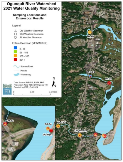
Map 1 Ogunquit River Watershed 2021 water quality monitoring sites. (Source: 2021 Water Quality Monitoring Report, FB Environmental Associates)
- A 2007 Watershed-Based Management Plan produced in partnership with the Wells
- A2013 Watershed-Based Management Plan update that included a watershed survey for nonpoint sources of
- Three implementation projects, referred to asPhases I, II, and III, carried out from 2014 to 2024, resulted in structural nonpoint source pollutant controls and involved educational outreach, funded in part by Maine A fourth phase has been funded and began in 2023.
- A septic system vulnerability assessment and comprehensive septic system database for all four towns within the watershed was developed in
Drinking Water Supplies
Best Management Practices and Regulatory Protection of Groundwater and Surface Water

Goals, Policies and Strategies
Goal
- Protect significant surface water resources from pollution and improve water quality where needed, especially the watershed and coastal areas.
- Minimize pollution from septic systems and sewer
- Coordinate with neighboring communities and local advocacy groups to protect water
- Monitor current drinking water
Policies:
- To protect significant surface water resources from pollution and improve water
- Monitor pollution discharges in coordination with Ogunquit Sewer
- Monitor effectiveness of private septic systems in coordination with the
- Continue to monitor drinking water
- Collaborate with neighboring communities and advocacy groups to protect water
- Actively seek long term solutions to estuary and beaches
Strategies:
- Priority: 1-5 with 1 being the highest priority.
| Description | Priority | Responsibility |
| Continue to support and participate in joint efforts to identify and remediate the sources of bacterial pollution in the rivers, streams, estuary, watershed and beaches. | 1 | Conservation Commission |
| Make water testing results at beaches, river(s), streams and estuaries readily available to users in real time. Collaborate with DEP Maine Healthy Beaches to improve communication of beach water quality. | 2 | Town Manager |
| Continue to assess that current catch basins are helping to decrease pollution, and periodically reexamine their functionality. Develop and follow a designated filter cleaning and replacement schedule in all catch basins to ensure maximum filter efficiency. Determine if additional catch basins need to be installed based on water quality findings along the beach and estuary. Encourage program of signage at storm drains to educate residents about protection of water quality. Work with Wells-Ogunquit School District to continue this program. Continue to upgrade the current GIS stormwater mapping program to identify if the infrastructure needs upgrade. | 3 | Town Manager |
| Update the current database of septic systems throughout the Town. Review Ordinance that requires evidence of septic system pump out at prescribed intervals. Determine if a septic system inspection is needed at prescribed intervals and if this should be added to the Ordinance. Determine if enforcement mechanism of septic Ordinances should be put in place. | 4 | CEO |
| Require landowners to replace any failing septic systems discovered in the watershed. | ||
| Establish a longer-term stormwater program for the Town, based on the 2020 census designating parts of the Town as “urban areas” and potentially requiring the Town to comply with a MS4 stormwater program. | 5 | Town Manager |
| Educate boat owners about cleaning hulls and propellers to avoid the spread of invasive species. | Harbormaster | |
| Adopt or amend local land use Ordinances as applicable to incorporate stormwater runoff performance standards consistent with: Maine Stormwater Management Law and Maine Stormwater regulations (Title 38 M.R.S.A. 420-D and 06-096 CMR 500 and 502). Maine Department of Environmental Protection’s allocations for allowable levels of phosphorus in ponds and watersheds. Maine Pollution Discharge Elimination System Stormwater Program. | Planning Board | |
| Support both public and private efforts to acquire and maintain conservation land to protect rivers, streams, estuary, watershed and wildlife habitats. | Town Manager | |
| Continue to require and monitor water quality protection practices and standards for construction and maintenance of public and private roads and public properties and require their implementation by contractors, owners and community employees and officials. | CEO | |
| Continually inform the community about the Town’s Pesticide and Herbicide Ordinance. Amend the Town’s Pesticide/Herbicide Ordinance to adopt a safe fertilizer Ordinance. | Conservation Commission | |
| Increase public education on disposal of pet waste in all areas of Town. Work with Healthy Rivers Ogunquit (HeRO) on this outreach project. Set uniform dates for allowing dogs on the beach and Marginal Way. Ensure that signage reflects the same dates and fines and that these are enforced. | Conservation Commission | |
| Continue to work with Ogunquit Sewer District to identify faulty sewer lines, test water quality in the estuary, and rectify any pollution discharges. | Conservation Commission | |
| Encourage landowners to protect water quality. Provide local contact information at the municipal office for water quality best management practices from resources such as Natural Resource Conservation Service, University of Maine Cooperative Extension, Soil and Water Conservation District. Maine Forest Service, and/or Small Woodlot Association of Maine. | Conservation Commission | |
| Enhance the Town’s existing land use regulations and policies by encouraging and/or requiring the use of low impact development (LID) and green infrastructure approaches for stormwater management for all development and redevelopment projects requiring site review. | Planning Board | |
| Require the Ogunquit Sewer District to conduct periodic sewer lateral testing. | Town Manager |