Chapter 10: Transportation
Introduction: Ogunquit’s Roadway Network
Roadway Network and Classifications
State Classification
In the early 1980s, the Maine Legislature authorized and directed MaineDOT to classify all public roads, which are referred to as highways by state and federal terminology,
throughout the State. The basis of this classification system was that roads serving primarily regional or statewide needs should be the State’s responsibility and roads serving primarily local needs should be municipal responsibility.
The State’s classification system is set out below:
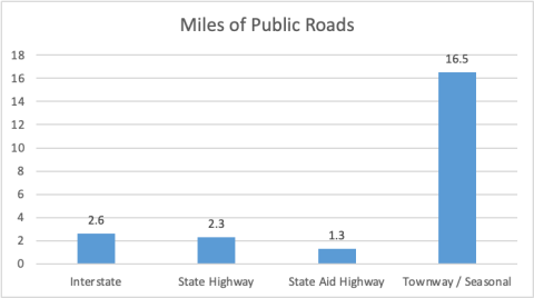
- State Highways form a system of connected routes throughout the state that primarilyserve intra- and interstate The State is responsible for all construction/reconstruction and maintenance on the 2.3 miles of arterial highway (Route 1) in Ogunquit.
- StateAid Highways connect local roads to the State Highway System and generally serve intracounty rather than intrastate traffic State aid roads are usually
- maintained by MaineDOT in the summer and by the municipalities in the winter pursuant to State Law 23 MRSA 1003. The State Aid Highway category generally corresponds with the federal ‘collector’ classification. Shore Road is the only State Aid Highway and is approximately 1.3 miles long.
- Townways are all other highways not included in the State Highway or State Aid Highway classifications maintained by municipalities or counties. These roads are classified as federal ‘local’ roads. There are approximately 4 miles of local roads in Ogunquit.
Federal Functional Classification
In addition to the State classification system, there is the Federal Functional Classification system. The federal system complements the State’s system and is based on the type of service the roadway is intended to provide. The federal classifications relate to traffic capacity and volume attributed to the roads and are divided into rural and urban systems. While State classification designates maintenance jurisdiction, federal functional classification creates a hierarchy of roads and determines which roads are eligible for federal highway funds. Functional classifications are reviewed after each census and updates are made to ensure classifications are in line with road functions.
There are three functional classes represented in Ogunquit as described below:
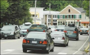
- MinorArterials are roads that place a greater emphasis on land access than the principal arterial and therefore offer a lower level of mobility. They serve as links between larger and smaller towns or as connections between collectors and the primary arterials. In Ogunquit, Route 1 is the only Minor Arterial and therefore eligible for federal aid.
- Major Collectors differ from arterial roadways due to size and general service area.Collectors serve traffic in a specific area, whereas arterials generally serve traffic moving through an Average trip lengths
on collectors are shorter than trips on arterials. Collectors gather traffic from local roads and streets and distribute it to the arterial. Major collectors are eligible for federal aid and include Shore Road in Ogunquit.
- Local Roads primarily provide accessto residential They are designed for low-speed travel and to carry low
volumes of traffic relatively short distances and are generally not eligible
Example of Minor Arterial Road
for federal aid funding for improvements or maintenance.
Traffic Volumes
| 2007-2013 | 2013-2019 | ||||||
| Traffic Counts Locations: 2007, 2013, 2019 | 2007 | 2013 | 2019 | Change | Percent | Change | Percent |
| Berwick Road west of US 1 | 2,250 | 1,880 | 2,290 | -370 | – 16.44% | 410 | 21.80% |
| Berwick Road at Maine Turnpike / York Townline | 1,010 | 810 | 1,080 | -200 | 19.80% | 270 | 33.33% |
| Agamenticus Road at York Townline | 920 | 650 | 800 | -270 | – 29.35% | 150 | 23.08% |
| Shore Road at York Townline | 2,310 | 1,700 | 1,900 | -610 | 26.41% | 200 | 11.76% |
| Shore Road southeast of Bourne Lane | 5,600 | 4,840 | 4,910 | -760 | 13.57% | 70 | 1.45% |
| Shore Road northwest of Obeds Lane | 6,420 | 5,110 | – | -1,310 | – 20.40% | – | – |
| Beach Street east of River Road @ Bridge 3492 | 2,680 | 2,620 | – | -60 | -2.24% | – | – |
| Perkins Cove Road southeast of Shore Road | 4,260 | 2,630 | 2,650 | -1,630 | – 38.26% | 20 | 0.76% |
| Captain Thomas Road west of Route US 1 | 1,090 | 890 | 1070 | -200 | – 18.35% | 180 | 20.22% |
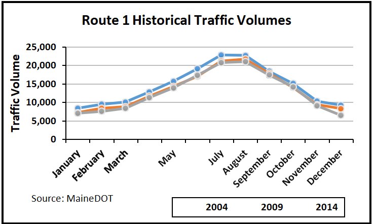
Until 2014, MaineDOT was collecting traffic data on U.S. Route 1 with a permanent traffic recorder, located just north of the intersection with Captain Thomas Road. Not surprisingly, the months of July and
August experienced the
most traffic along U.S. 1 in Ogunquit. Between 2004- 2009, the traffic volume decreased, with all
months experiencing at least a 2.8% reduction. Between 2009-2014, the traffic volume still decreased, but less significantly. These decreases are most likely a result of the economic downturn that began in 2008.
| US Route 1 (Bridge over Ogunquit River) at Wells town line | ||||
| Year | 2018 | 2019 | 2020 | 2021 |
| AADT | 12,460 | 13,140 | NA | 13,530 |
| Source: MaineDOT | ||||
Pavement Conditions
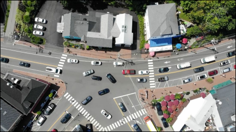
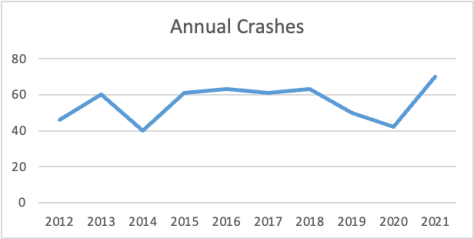
Crash History and Trends
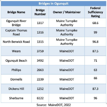
Bridges
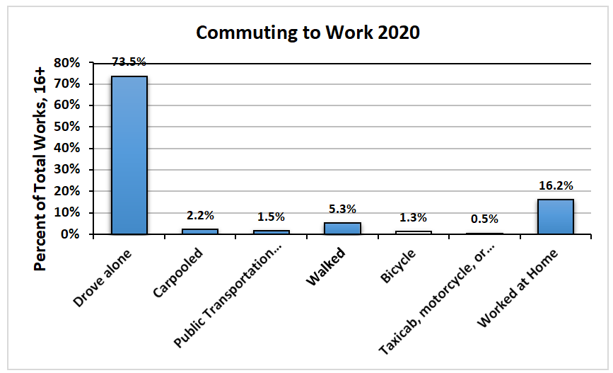
Ogunquit’s Transportation Users
Alternatives to single occupancy vehicles
Bicycling and Walking
Ogunquit Trolley
Amtrak Downeaster at Wells Transportation Center via Shoreline Explorer
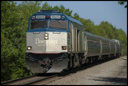
The Amtrak Downeaster is a passenger rail service that runs from Boston, Massachusetts to Brunswick, Maine. The closest station is located at the Wells Transportation Center. Although
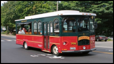
there is no public transportation connecting the Amtrak Downeaster to Ogunquit, in previous years, during the summer, the Trolley Service connected with the Shoreline Explorer through to the Wells Transportation Center. The Blue Line Trolley Service will not operate in 2024.
Bus and Other Services
While there are no commercial bus services in Town,C&J Bus runs out of Portsmouth, NH, and residents
Downeaster service to Boston
often use its services for trips to Boston and New York
City, among others. C&J service from NYC to Ogunquit was recently discontinued. Tourist buses bring many visitors to town. York Hospital provides free transport services to several of its area facilities.There are no local airports nor ferry services in Ogunquit.
There are paid docking berths available in Perkins Cove for private vessels.
Land Use and Transportation Planning Framework
Review of Land Development Applications and Impacts Mitigation
Zoning Requirements and Transportation Implications
Regional Transportation Planning
Regional Transportation Planning
Complete Streets Policy
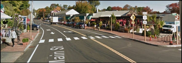
As mentioned earlier, U.S. Route 1 (Main Street) through Ogunquit was recently reconstructed by MaineDOT. The photo above was taken after the project was completed and is a great example of a Complete Street.
Other Existing Facilities
Electric Vehicle Charging Stations
MaineDOT, the Maine Turnpike Authority, Maine Department of Environmental Protection (DEP), as well as other agencies and organizations across Maine have been preparing a number of initiatives relating to the deployment of all electric and plug-in-hybrid vehicles. State and local governments, as well as public utility companies and private businesses have been working to expand the number of electric vehicle charging stations. There are EV charging stations located within the Town:
- 518Main St: The Dunes on the Waterfront
- 62Beachmere Place: The Beachmere
- 74Main St: Meadowmere Resort
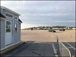
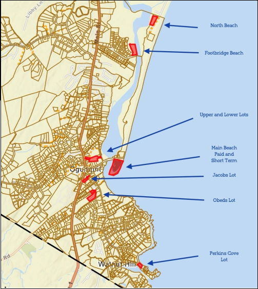
These stations are located on private property but are publicly accessible. Multiple EV stations are located in the Obeds Parking Lot adjacent to the Dunaway Center.
Public Parking
Conclusion
Ogunquit’s transportation network is generally in good condition. It comes under less pressure in the winter when traffic volume drops. As Ogunquit is likely to remain a highly desirable tourist destination, the need to accommodate vehicles in terms of both road capacity and parking will remain.
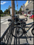
The seasonal nature of Ogunquit’s economy sees an increase in people walking, cycling, and using the trolley service in the warmer months. New mobility concepts including e-bikes, scooters, bikeshare, and rideshare, offer alternative modes of travel within the town without additional strain on the street network. These options are more affordable than cars for seasonal workers.
However, allowing these travel modes to mix safely with cars and pedestrians will need creative interventions in allocating street space. Proliferation of electric vehicle charging, aided by efforts from Efficiency Maine and Maine DEP, offer additional opportunities to facilitate low-carbon transport.
Goals, Policies and Strategies
Goal
- Tomake it safer and easier to move to, from and around Ogunquit for everyone, irrespective of their mode of
Policies:
- Toprioritize community and regional needs by the safe, efficient, and optimal use of transportation
- Tomeet the diverse transportation needs of residents and
- Topromote public health and enhance livability by maximizing the efficiency of the transportation system and minimizing increases in vehicle miles traveled.
- Tomaximize the efficiency of the State and State-Aid Highway network.
- Tocreatively increase parking capacity to relieve
Strategies:
- Priority: 1-5 with 1 being the highest priority.
| Description | Priority | Responsibility |
| Identify traffic conflict points, such as the location of crosswalks which are causing delays on Route 1, and recommend remedial action. | 1 | Town Manager |
| Execute feasibility study for satellite parking lots including a shuttle/trolley to take people to and from town. | 2 | Visitor Services |
| Increase public transportation including options to bring key workers to and from Ogunquit, shopping areas and link to the Wells transport hub. | 3 | Town Manager |
| Identify and remedy potential accident locations including improving visibility where sightlines are poor. | 4 | Public Works |
| Add signs on Route 1 to provide information about the availability of parking spaces in beach lots. | 5 | Visitor Services |
| Consider a non-motorized transportation plan for Ogunquit, such as the creation of additional sidewalks. | Bicycle-Pedestrian Committee | |
| Establish a comprehensive rolling program of road maintenance, including identifying more durable road surface materials. | Public Works | |
| Initiate or actively participate in regional and state transportation efforts. | Town Manager | |
| Maintain, enact or amend local ordinances as appropriate to address or avoid conflicts with Maine State law. | CEO | |
| Maintain, enact or amend ordinance standards for subdivisions and for public and private roads as appropriate to foster transportation-efficient growth patterns and provide for future street and transit connections. | Planning Board | |
| Explore options for regional delivery of local services. | Town Treasurer | |
| Maintain, enact, or amend local ordinances as appropriate to address or avoid conflicts with: Policy objectives of the Sensible Transportation Policy Act (23 M.R.S.A. §73); State access management regulations pursuant to 23 M.R.S.A. §704; and State traffic permitting regulations for large developments pursuant to 23 M.R.S.A. §704-A. | Town Manager | |
| Evaluate options for the use of electric bikes in Ogunquit. | Bicycle-Pedestrian Committee | |
| Analyze and make recommendations for remodeling intersections that are not at 90° (e.g. School Street and Rte. 1, Bayview Ave. and Ocean St.) to improve safety for alternate road users. | Public Works | |
| Analyze and make recommendations for adding curbs to protect pedestrians without impacting bicyclists. | Public Works | |
| Explore options for local transportation services. | Visitor Services |