Chapter 15: Climate Change and Sea Level Rise

Purpose

Much of Ogunquit’s identity, economy, and population are inextricably tied to, dependent on, and concentrated along its coastline, making coastal climate impacts of critical concern for the town. As such, this chapter will focus on sea level rise rather than climate change in general.
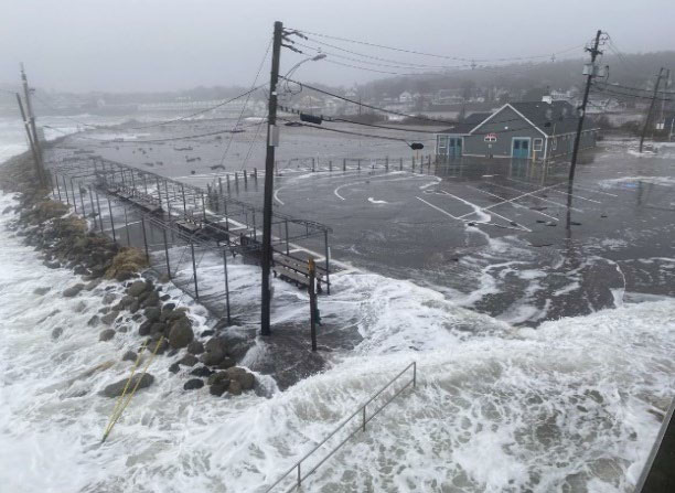
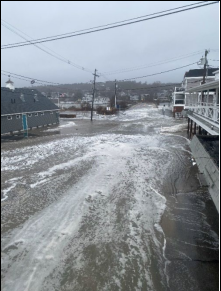
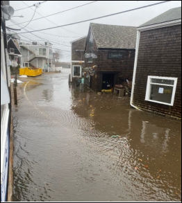
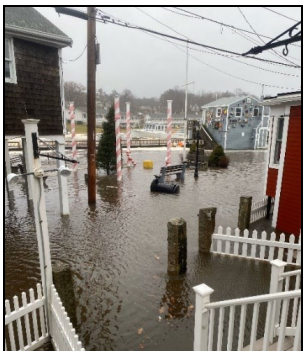
The future of Ogunquit depends on how ably the town, working with its neighbors, addresses and mitigates the threat of climate change and sea level rise – a threat brought home by the devastating storm of January 13,2024.
Climate change is already impacting Ogunquit and poses significant threats to the community, including its beaches, natural resources, historical and cultural resources, infrastructure, people, and economy. Warming air and ocean temperatures, shifting precipitation paterns, more frequent and intense storm events, sea level rise, increasing risk of drought, habitat loss, reduced biodiversity, and increasing prevalence of vector-borne diseases such as Lyme are just some of the climate hazards and impacts facing the Town.

Climate change will exacerbate existing hazards and issues, but also cause new risks and challenges for Ogunquit. Intense precipitation events could cause more storm water run off, amplifying existing water quality problems. 

Increasing storm intensity and frequency will likely cause more power outages that last longer, disrupting the community’s normal activities, impairing public safety, and straining local resources. Shifting terrestrial habitat conditions and warming ocean temperatures could encourage the expansion of existing invasive species, like green crab and knotweed, and enable the arrival of new invasive species, jeopardizing traditional recreation and fishing activities like shellfish harvesting. Extreme heat and drought will threaten public health and natural resources.

Extreme heat and drought will threaten public health and natural resources.

The Community likely has an elevated level of vulnerability to natural hazards and climate impacts.

While climate change will likely impact every facet of the community in some way, those impacts will not be felt evenly across the community and will not be uniformly distributed among population groups. Individuals who already have increased social vulnerability or have  been traditionally marginalized and underrepresented will be disproportionately affected by climate hazards, as they generally have lower capacity to prepare for, respond to, and recover from hazard events and disruptions.

Those populations include children and older adults, households with lower or moderate incomes, individuals with pre-existing health conditions, people of color, and those living alone. Ogunquit has relatively high percentage of older individuals (65+) living alone, characteristics that contribute to elevated social vulnerability as they tend to be associated with social isolation and decreased ability to prepare for and respond to storms, flooding, and other natural disasters. As a result,the community likely has an elevated level of vulnerability to natural hazards and climate impacts.

Ogunquit has a relatively high percentage of older individuals (65+) living alone, characteristics that contribute to elevated social vulnerability as they tend to be associated with social isolation and decreased ability to prepare for and respond to storms, flooding, and other natural disasters.

Sea Level Rise Background

Climate Change and Sea Level Rise

Ogunquit can expect to see a 15- fold increase in coastal flooding by 2050.


Sea level rise is a global phenomenon driven by two primary factors related to climate change: an increase in the volume of ocean water caused by the melting of land-based ice sheets and glaciers, and thermal expansion of seawater as it is warmed by increasing global temperatures. While sea level in Maine has been rising in the long-term, over the past few decades the rate of rise has accelerated. Nearly half of the documented sea level rise that has occurred locally over the past century has happened since 1993, representing a rapid increase in the rate of change.

That rise is increasing the frequency of nuisance or high tide flooding, with southern Maine seeing four times as many nuisance flooding events over the last decade compared with the average of the past 100years. According to a State 2020 study, under intermediate global greenhouse gas emissions scenarios there is a 67% probability that sea level will rise between 1.1 and 1.8 feet by 2050, and between 3.0 and 4.6 feet by the year 2100 relative to 2000 water levels, with higher sea level rise amounts possible. With that rate of sea level rise, not accounting for increased intensity and frequency of storms, Ogunquit can expect to see a 15-fold increase in coastal flooding by 2050. Those scenarios do not account for more intense rainfall that climate change is bringing to the region, which will exacerbate flooding.
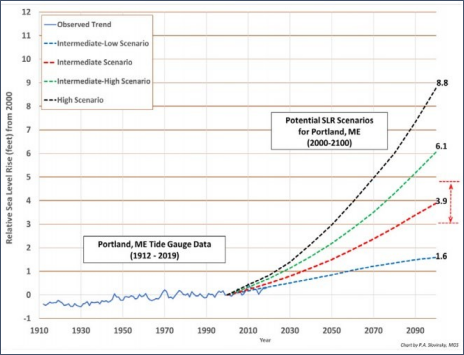
Graph illustrating historical sea level rise in Portland (solid blue line) and scenarios from 2000-2100 with central estimates (50% probability of being met or exceeded) for low-intermediate to high sea level rise scenarios. The likely range of 3.0 to 4.6 feet (67% probability of sea level rise falling between these values) for the intermediate scenario is shown as a dashed red arrow and red lines on the right side of the figure. Values are presented in tenths of a foot and relate to a year 2000 starting point. Scenario data from the

U.S. Army Corps of Engineers Sea Level Change Calculator based on sea level rise scenarios developed for the 4th U.S. National Climate Assessment. (Source: Scientific Assessment of Climate Change and Its Effects in Maine prepared by the Maine Climate Council Scientific and Technical Subcommittee. Chart by P. Slovinsky, Maine Geological Society)
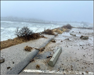
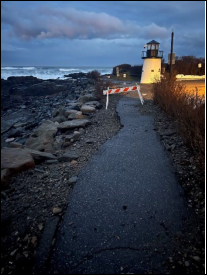
Historically, coastal flooding has been the most common type of weather-related disaster in coastal southern Maine, causing an average of $800,000 in property damage annually across the region since the mid-1990s. As sea level rises in the future, normal high tides will be higher and storms, and accompanying storm surge (the abnormal rise in ocean water level above the normal predicted astronomical tide during a storm event), will be more impactful, causing extensive coastal flooding to roads, homes, and businesses. Storm surge can cause extreme flooding in coastal areas, especially when storm surge coincides with normal high tide, as was the case during a late December 2022 coastal storm when Ogunquit experienced a roughly 2.5-foot surge that hit at high tide causing significant and damaging tidal flooding leading to road closures and extensive power outages. The December 2022 storm and more recent January 2024 storm highlighted Marginal Way after storm how increasing storm intensity and frequency coupled with sea level rise will impact the community. Of local concern is the impact of power outages from future storms on Ogunquit’s relatively large population of vulnerable older residents who rely on medical services and equipment that require electricity. While future sea level rise will occur gradually over time, extreme storm events can cause damaging flooding episodically in the short-term.
Maine is experiencing more frequent and intense precipitation events.
In addition to rising seas, storm surge, and more nuisance flooding events, southern Maine is experiencing more frequent and intense precipitation events. As noted above, the intensity and frequency of precipitation is expected to increase in the future with climate change. Stormwater runoff from intense rainfall events combined with storm surge and future sea level rise will lead to more extensive flooding, potentially increasing pollution and intensifying water quality issues in Town. That threat is further exacerbated by development pressure throughout the Ogunquit River and Josias River Watersheds and increasing impervious coverage within the region. Precipitation events can cause widespread flooding and damage, especially when coupled with elevated ocean water levels.

Sea Level Rise Impacts on Ogunquit
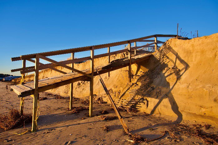
Sea level rise is projected to cause regular inundation of low-lying coastal areas during high tide; contamination of groundwater and drinking water wells from saltwater intrusion; septic system failure from flooding and elevated groundwater levels; and increased erosion of the coastline, including sandy beaches, dunes, and salt marshes. In Ogunquit, beaches, marshes, beach parking areas, cultural and historic resources, coastal roads, water and sewer infrastructure, and the wastewater treatment plant are at risk of flooding. The concentration of residential and commercial development in coastal areas, tourism-based economy, and proximity of significant community resources, like the Marginal Way and Perkins Cove, to the coastline make Ogunquit particularly vulnerable to sea level rise. The Town has undertaken efforts to improve its understanding of flood risks of and vulnerabilities to sea level rise by participating in several regional sea level rise and coastal resilience planning projects.
As storms and rising seas erode beaches and damage beach-dune systems, some of the natural and recreational services that beaches provide will disappear, resulting in tangible losses to the local economy.
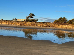
Ogunquit’s beaches are vital economic, recreation, and cultural resources for the town. As storms and rising seas erode beaches and damage beach-dune systems, some of the natural and recreational services that beaches provide will disappear, resulting in tangible losses to the local economy. There is already a minimal dry beach around the southern end of Main Beach during regular high tide. Shoreline data collected annually by the Maine Geological Survey (MGS) through the Maine Beach Mapping Program show that overall, Ogunquit’s beach and dune areas are not experiencing erosion from year to year, but rather are accreting or growing slightly.
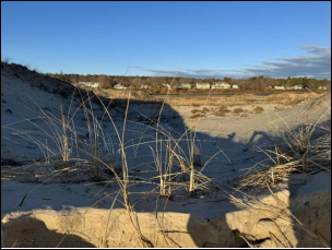
According to MGS, from 2017 to 2021, Ogunquit saw strong positive trends in dune and beach change, while the mean dry beach width stayed about the same. From 2020-2021, dry beach width decreased near the river, but increased along most of the beach. Despite the current positive trends, sea level rise is expected to accelerate the rate of erosion and cause more beach areas to be inundated during tidal cycles. An assessment by the MGS reveals that 1.6 feet of sea level rise will reduce Dune erosion Ogunquit’s dry beach area by 42%, which could happen by 2050 or earlier depending on the rate of sea level rise and natural sand supplies.
An assessment by the MGS reveals that 1.6 feet of sea level rise will reduce Ogunquit’s dry beach area by 42%, which could happen by 2050 or earlier depending on the rate of sea level rise and natural sand supplies.
That finding has serious implications for Ogunquit’s economy, as well as for the overall community, its residents, and local businesses that rely on having healthy beaches to support tourism and recreation.
In addition to the beaches themselves, beach parking areas are critical assets for the Town. The Main Beach parking lot, Footbridge Beach parking lot, North Beach parking lot, and the Lower Lot are vulnerable to sea level rise, as are road access to the lots and footpath access from the lots to the beaches.
Loss of beach parking during and after coastal storms is a serious risk to Ogunquit’s fiscal health as the revenues represent 20% of the municipal budget.
Flooding of those areas could result in costly damage to pavement and parking lot infrastructure and lead to partial or entire closures of parking lots for extended periods of time. Depending on when these closures occur (during the tourist season or off-season), they could result in decreased parking revenue and beach visitation. Municipal data show that the Town’s public beach lots brought in over $3 million annually during the fiscal years ending in 2018-2020.
That revenue makes up over 20% of Ogunquit’s municipal budget. Therefore, loss of beach parking during and after coastal storms is a serious risk to Ogunquit’s fiscal health. Additionally, access to parking is a key determinant of beach visitation. If future sea levels rise and coastal storms decrease the availability of beach parking, beach visitation and beach-centered tourism in Ogunquit could change as well. Historic and cultural assets that are significant drivers of tourism, including Perkins Cove, Wharf Lane, and the Marginal Way, are also vulnerable to sea level rise. Sea level rise modeling shows that the Marginal Way itself is not projected to be directly impacted by flooding from 1.6 or 3.0 feet of sea level rise combined with storm surge. However, the path already experiences significant erosion damage during storm events from pounding waves and high-water levels. Sea level rise will cause elevated base water levels that will likely cause higher storm tide water levels and worsening erosion from more intense and direct wave action potentially resulting in loss of integrity to the path and safety concerns.
Perkins Cove and the Marginal Way are also vulnerable to sea level rise.
In addition to impacts to the tourism economy, sea level rise, and climate change in general, pose risks to municipal fiscal health. Like other coastal communities in Maine, Ogunquit’s municipal budget is highly dependent on revenue from local property taxes and coastal Waves pounding Marginal Way (Photo: Joan Griswold) development provides a substantial portion of the municipal tax base, generating vital funds that sustain community operations, services, and programs. However, it is that same development that is most susceptible to coastal flooding, placing residents, visitors, and municipal tax revenue at greatest risk. Studies have shown that coastal hazards and climate change diminish the value of impacted properties.
Ogunquit’s municipal budget is highly dependent on revenue from local property taxes and coastal development provides a substantial portion of the municipal tax base, generating vital funds that sustain community operations, services, and programs.
A 2022 study by SMPDC found that coastal properties totaling approximately $98,900,000 in assessed value are exposed to flooding from 1.6 feet of sea level rise combined with storm surge. That figure increases to $112,200,000 with 3.0 feet of sea level rise combined with storm surge, representing 10% of the Town’s FY2021 municipal budget. Municipal fiscal health could be affected as coastal properties, which generate a large portion of local tax revenue, are increasingly exposed to flooding and potentially decrease in value due to the increasing flood risk. Most of the properties at direct risk of flooding in Ogunquit are designated as uses other than residential single-family homes, amplifying potential negative impacts to the local economy.
Road flooding poses risks to public health, safety, and wellbeing as it disrupts local travel.
Ogunquit has 0.7 miles of road vulnerable to 1.6 feet of sea level rise plus storm surge, almost 0.5 miles of which are local roads. Road flooding poses risks to public health, safety, and wellbeing as it disrupts local travel, the provision of emergency services, and access to emergency evacuation routes in town. Additionally, flooding can cause costly damage to road infrastructure. Roads that are vulnerable to flooding from sea level rise include Beach Plum Lane, River Road, Ocean Street, Riverbank Road, Beach Street, Bridge Street, Lower Lot Road, and Perkins Cove Road.
The Ogunquit Sewer District’s (District) wastewater treatment plant, access to it via Ocean Avenue in Wells, and pump station are extremely vulnerable to sea level rise. The plant, which is in a coastal sand dune system, is projected to experience significant inundation in the 1.6-foot scenario and is entirely inundated by the 3.0-foot scenario. It has experienced significant flooding in the past, particularly during the Patriot’s Day Storm in 2007.
Both the Ogunquit Sewer District and the Town have undertaken or been involved with studies to examine the impacts of sea level rise, storm surge, and flooding at the plant. Considerable measures are being investigated and implemented by the District to reduce the critical facility’s vulnerability to flooding by relocating it inland to an area of lower flood risk. The District purchased land outside of the designated regulatory floodplain to eventually relocate the treatment plant as necessary. The District has also moved existing electrical equipment out of the flood-prone basement of the plant, installed flood gates on entry doors, and is planning to elevate other critical equipment to mitigate flood impacts.
Considerable measures are being investigated and implemented by the District to reduce the critical facility’s vulnerability to flooding by relocating it inland to an area of lower flood risk.
The Gulf of Maine is warming faster than 97% of the world’s oceans. Ocean acidity levels have already risen 30% and will continue rising alongside growing greenhouse gas levels.
While sea level rise and coastal flooding threaten both commercial and recreational fishing activity through direct impacts to harbor infrastructure at Perkins Cove and access to that infrastructure, there are additional climate-related impacts on the marine environment. Water quality issues negatively impact coastal wildlife, including commercially harvested species. Additionally, climate change causes both warming and acidification of marine waters. The Gulf of Maine is warming faster than 97% of the world’s oceans.
Ocean acidity levels have already risen 30% and will continue rising alongside growing greenhouse gas levels. Ocean acidification has already impacted some shellfish harvesting operations statewide and will increasingly affect marine organisms that produce calcium carbonate to build shells, such as oysters, scallops, clams, mussels, and sea urchins. These combined climate impacts will lead to some marine species migrating northward to colder water and disappearing from traditional fishing grounds. This is expected to reduce catches and associated revenue for local fishermen and could detrimentally impact Ogunquit’s recreational fishing activity. See htps://smpdc.org/rsrp for further information.
Climate impacts will lead to some marine species migrating northward to colder water and disappearing from traditional fishing grounds. This is expected to reduce catches and associated revenue for local fishermen and could detrimentally impact Ogunquit’s recreational fishing activity.

Impacts to Marshes

Maine’s State shoreland zoning regulations define coastal wetlands as all tidal and subtidal lands which have salt water tolerant vegetation present and any marsh, bog, swamp, beach flat or lowland that is subject to tidal action during the highest tide level. These coastal wetlands can also include portions of the coastal sand dunes. Ogunquit is protected by coastal wetlands called marshes. Low marsh is defined as intertidal marsh: it is exposed and covered by the tide each day. High marsh is defined as the area of salt marsh that is sporadically only covered by water. Marshes are important to the ecosystem. They provide pollution filtering, slow and buffer water during coastal flood events and provide a wildlife habitat. They are also important in slowing erosion in areas. As in many Maine communities, marsh migration can be an issue for Ogunquit. Flooding from sea level rise poses a threat to Ogunquit’s coastal wetlands at risk of flooding in Ogunquit.
As in many Maine communities, marsh migration can be an issue for Ogunquit. Flooding from sea level rise poses a threat to Ogunquit’s coastal wetlands at risk of flooding in Ogunquit.
Our carbon output, such as tailpipe and factory emissions, contribute to climate change. Anything that soaks up carbon dioxide helps to offset what we put out into the world. Blue carbon reservoirs, such as marshes, salt hay and eel grass slow climate change by trapping carbon dioxide in the marsh.
Small amounts of sea level rise have the potential to cause extensive changes to marshland such as the inland migration of marshes. When sea level rise increases, high marsh environments cannot survive the increase inundation. This leaves only low marsh environments. This decreases the diversity of saltwater marsh and diminishes its ability to buffer the shoreline from erosion. If the sea level rises too rapidly or abruptly, it can drown the low marsh, leaving the shoreland unprotected. Marshes can migrate landward to keep pace with sea level rise when there are no physical barriers (e.g., houses, roads, rock walls, etc.) hindering their migration.
If the sea level rises too rapidly or abruptly, it can drown the low marsh, leaving the shoreland unprotected.

Storms and Potential Hurricanes

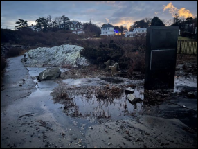
Due to climate change, storms are more intense than in earlier decades with heavier rainfall and higher winds. Because of Maine’s tidal variation, the potential combination of astronomical tide and storms is concerning. Potential hurricane inundation mapping has been done in Maine through a FEMA grant to Maine’s Floodplain Management Office in consultation with the National Hurricane Partnership representatives on tool development, proposed process and techniques. Modeling potential hurricane inundation scenarios can assist towns with investigating potential impacts on critical Main beach, Marginal Way, and Perkins Cove flooding after 1/24 storm infrastructure, emergency management, community outreach and education.
Lastly, flooding from sea level rise poses a threat to Ogunquit’s coastal wetlands and the vital services they provide (e.g., wildlife habitat, water filtration, flood mitigation, and absorption of wave energy), as it can drown saltmarsh vegetation. According to a 2013 study by the National Oceanic Atmospheric Administration, there are 97 acres of coastal wetland at risk of flooding in Ogunquit. The January 2024 storms, with beach and dune damage, coastal flooding at Perkins Cove, and damage to the Marginal Way starkly illustrate Ogunquit’s exposure.
Flooding from sea level rise poses a threat to Ogunquit’s coastal wetlands and the vital services they provide (e.g., wildlife habitat, water filtration, flood mitigation, and absorption of wave energy).

Climate change poses an existential threat to Ogunquit. The rise of sea level is of concern for the Town, as it threatens the coastal community’s character, economy, public safety, infrastructure, and natural resources. Ogunquit is already taking action to plan for climate change by participating as a founding member in the Southern Maine Regional Sustainability and Resilience Program, enrolling in the State’s Community Resilience Partnership program, undertaking watershed studies and stormwater management improvements, conserving important natural areas, participating in regional coastal resilience planning projects, converting streetlights to LEDs, pursuing funding to install solar panels on the Dunaway Center, converting portions of the municipal fleet to electric vehicles (EVs), and installing EV charging stations in municipal parking lots. Continued commitment to climate action will be critical in the future to ensure the sustainability and resilience of the community.
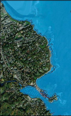
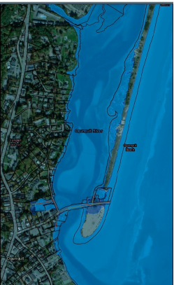
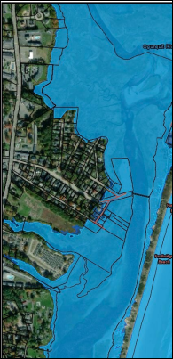
Projected inundation from 1.6 and 3.9 feet of sea level rise combined with storm surge from the 1% annual chance event overlayed with Ogunquit parcels. Impacted roads account for bridge elevation, as LiDAR was used to confirm whether a bridge would be overtopped based on bridge deck elevations and the water surface elevations of the inundation scenario. If the inundation boundary appears to ‘cover’ a bridge, the bridge is only projected to be inundated by water if it is shown as red or orange on the map. (Source: SMPDC. 2022. Economic Resilience Assessment and Plan for Coastal York County).

Goals, Policies and Strategies

Goal

  • Toacknowledge and respond to the full potential of climate change impacts on residents,
properties and natural resources

Policies:

  • Tocontinue to monitor the effects of sea level and climate change and their impact on the Town of
  • Reviewand update polices and ordinances
  • Usecost benefit analysis to make decisions regarding any new retrofitting and fortification as needed due to sea level rise or climate change.

Strategies:

  • Priority: 1-5 with 1 being the highest priority.
Description Priority Responsibility
Continue to work with Maine’s southernmost coastal communities and SMPDC to assess impacts of coastal hazards, including sea level rise and erosion. Develop strategies and nature-based solutions for making the region(s) more resilient to coastal hazards and research grants to fund these solutions. 1 Town Manager
Identify and prioritize Ogunquit’s most vulnerable areas for sea level rise such as: · Ogunquit Beach, Footbridge Beach and North Beach and parking lot, roads leading to the beach, residential and commercial businesses in beach area. · Perkins Cove and waterfront, Perkins Cove Road, Parking lot, commercial and residential buildings. · Rocky coastline, especially in the area along the Marginal Way path which features basaltic dikes, glacial features and sedimentary rocks. · Ogunquit Sewer Treatment Plant. Ogunquit Sewer District has already purchased land outside of the floodplain, relocated electrical equipment and is planning on staging emergency equipment off site. Develop plans/solutions to protect the people, infrastructure and natural resources in vulnerable areas. 2 Town Manager
Analyze the economic impact of sea level rise and climate change on identified vulnerable areas and develop long- range plan(s) to combat negative economic changes to the Town and residents.   Identify and secure the type of capital investment needed to safeguard at-risk infrastructure. 3 Town Manager
Develop an evacuation plan for residents and visitors in areas vulnerable to sea level rise. 4 Town Manager
Continue to increase the use of renewable energy resources (such as solar panels on Town structures and in parking lots), make carbon-free decisions and use cost effective materials created from recycled material. Educate and encourage homeowners to do the same. 5 Town Manager
Develop an education plan, in collaboration with residents and businesses, to educate residents and businesses as to what steps the Town is taking to address and plan for climate change and sea level rise.   Sustainability Committee
Annually review floodplain management and land use ordinances to protect vulnerable areas, especially set-back areas in shoreland areas.   CEO
Continue to research and recommend suggestions to reduce carbon emissions, beach erosion, soil erosion and maintain Best Management Practices (BMP) for stormwater run-off to Select Board.   Sustainability Committee
Educate and enforce the Maine Statute that prohibits idling vehicles.   Police Department
Encourage the planting of additional trees on Town property and residential property to provide shade and conserve energy.   Conservation Commission
Increase fines and tighten enforcement for trespassing on the dunes.   Town Manager