Chapter 1: Historical and Archaeological Resources

History of Ogunquit

Precontact

The name “Ogunquit” was mentioned in early documents primarily in reference to the river. The application by the Reverend John Wheelwright for the first sawmill sited its location on the “Agunquat” River. The meaning has long been thought to derive from the Natick tribe, meaning “Beautiful Place by the Sea,” (which the Town still uses) but more recent scholarship casts doubt on that origin. It may come from the Micmac “pog-um-ik,” meaning lagoons formed at the mouth of rivers. While the exact origin of the term is not known, “Beautiful Place by the Sea” is considered by many to sound most descriptive of Ogunquit.

Colonial Era to Mid 19th Century

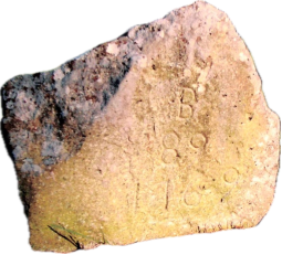
In the early years of European settlement, travel was difficult due to the lack of usable roads. An order from Massachusetts was issued in 1653 to build a road by the sea. This road was improved through Ogunquit Village in 1664, and the King’s Highway was extended from Portsmouth to Saco in 1719. A mile marker from 1769 still exists in Town, marked “B 89 1769,” meaning Boston 89 miles. In 1716, Wells was indicted by the General Court for not having a school. So, in 1717, a school was opened in the home of Colonel John Wheelwright in Wells for the first quarter of the school year, moving in the next quarter to Daniel Littlefield’s house in Ogunquit. The town later hired Richard Dean as the teacher and built its first school in 1730. 1769 mile marker Ongoing conflict with Native Americans and other economic hardships kept growth and industry to a minimum until 1760 when the last of the treaties were signed. Then subsequent national wars (French and Indian Wars, Revolutionary War, and the War of 1812) and their associated economic downturns conspired to repeatedly slow growth all along the New England coast. By 1825, farming, shipbuilding, and trade had resumed, and taverns sprung up to accommodate an increasing number of stagecoach riders. By the end of the 19th Century, Ogunquit had become a busy port at wharfs near the end of the Ogunquit River. During this era, William Henry Perkins began building the iconic Ogunquit Dory in his boat house on what is still called Wharf Lane; a modern re-creation today lies at the Winn House. Cargo ships plied their way from Ogunquit to Boston and along the coast. Several sea captains built large homes in town, some of which are still in existence.

Beginning of the Artist Colony Era

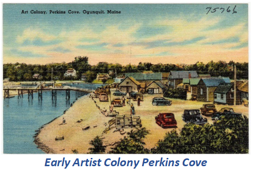
Ogunquit’s art future began in the late 1800s, as artists drawn to Perkins Cove by its summer beauty attracted other people. Summer visitors began to arrive with regularity, especially with the advent of trains and trolleys. Ogunquit Beach first became accessible in 1888, when a bridge was built across the Ogunquit River at Beach Street. There were grand hotels built in Ogunquit for the summer boarders, who would ride the train to Wells Beach Station and then take a carriage to Ogunquit. Some of those hotels still exist, such as the Colonial Inn, on the National Register of Historic Places, and the Aspinquid and Sparhawk. Others followed, including the Ontio and Lookout hotels, now converted to condominiums.
Ogunquit residents formed the Ogunquit Beach District with the approval of the State legislature.
The Nellie Littlefield house was built in 1889 and has been restored as a Bed and Breakfast. Around this same time, developers, known then as “capitalists,” were buying up shoreland from local owners who found it amazing that such poor, rocky, sandy land was desirable simply because of its view. Several famous tea houses attracted residents and tourists alike, including the Whistling Oyster (now Barnacle Billy’s), Barbara Dean’s, and the Dan Sing Fan house, famous for its cinnamon toast and jasmine tea, overlooking Perkins Cove.

Protecting Natural Resources

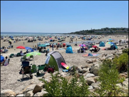
1913 saw the incorporation of the Ogunquit Village Corporation. A pivotal moment in Ogunquit’s history occurred in the early 1920s, when it was discovered that a Wells developer had purchased the entire shoreline down to the southern tip of Ogunquit Beach. As cottage development marched south from Moody Beach, Ogunquit residents formed the Ogunquit Beach District with the approval of the State legislature to tax themselves for the express purpose of funding eminent domain proceedings. This extraordinary and prescient act by far-seeing Ogunquit residents resulted in the beach being saved at the cost of $43,500 (half of which were legal fees) several years later. The property today is priceless to the Town and its many visitors. Ogunquit Beach (legally a park per the Act to Incorporate the Ogunquit Beach District dated April 1, 1923) is today a beautiful public beach.
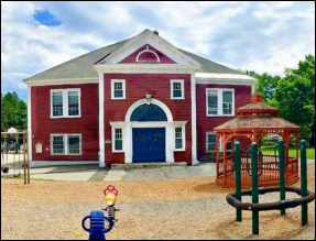
In 1907, Ogunquit built a larger school on land donated by John J. Littlefield. In 1929, the Ogunquit Village School (OVS) was enlarged at the current site. When Ogunquit was incorporated as a separate town in 1980, the Wells Ogunquit school district took over and used OVS until it was closed in 2004. In 2023, the Town voted to demolish the school to make space for a new police station and town hall. The new building will retain the overall appearance of the original school, while providing modern facilities.
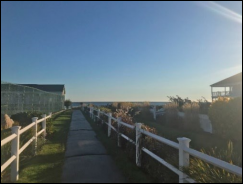
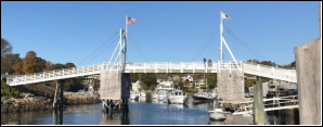
Perkins Cove began as a small fishing village but its rustic shacks, lapstrake dories, rocky outcroppings and churning waves made it an artists’ paradise. As a result, it soon emerged as a mecca for artists especially with the advent of two art schools with renowned teachers of painting and sculpture. The Cove’s saltmarsh was dredged in 1940-41 and a drawbridge was built across the channel in 1944 to replace earlier rickety footbridges and allow larger boats access to the protected harbor. To manage the harbor moorings, the Town appointed William Tower Jr. as the first Harbormaster in 1944. Another far-reaching event occurred in 1925, when Josiah Chase, a wealthy conservationist and former legislator, gave one mile of what is now known as the Marginal Way and approximately another mile of access paths to the Town. Other benefactors added ten-foot- wide shoreline easements, eventually forming the 1.25- Perkins Cove mile Marginal Way. Originally a narrow path requiring climbing over rocks and running to the Cliff House, it was paved in 1960 and is now wheelchair accessible, and ends at Perkins Cove. This path, with its views and benches at the ocean’s edge, is beloved by residents and tourists alike.
In 1925, Josiah Chase, a wealthy conservationist and former legislator, gave one mile of what is now known as the Marginal Way to the Town.
The Marginal Way Committee is responsible for identifying projects to enhance the Marginal Way and makes these recommendations to the Select Board. For example, the committee annually attracts volunteers to replace invasive plants with native Maine flora. The Marginal Way Preservation Fund, Inc. (a non-profit organization) administers an endowment fund which helps defray the Town’s costs associated with preserving and maintaining it. In 2016, a new 8,000 square-foot garden featuring native plantings was installed in the Marginal Way.

Tourism Growth

Following World War II and the building of the Maine Turnpike between Portland and Kittery, Ogunquit truly became a destination community as the middle class took to their cars and to the roads to visit the seashore and vacation. The 1950s and 1960s saw robust residential/seasonal and commercial growth in the Town. The artist colony expanded when Charles Woodbury founded the Ogunquit Summer School of Drawing and Painting, and Hamilton Easter Field founded the Summer School of Graphic Arts in 1911. In 1928, the Ogunquit Beach Ogunquit Art Association (now housed at the Barn Gallery) was established. The Ogunquit Museum of American Art was founded by Henry Strater, on land purchased from Charles Woodbury’s family, in 1953. The Ogunquit Playhouse was founded in 1933 in a converted garage as a summer stock theater. Walter and Maude Hartwig built the current playhouse in 1937 and brought famous Broadway and Hollywood stars to town to perform.
John Lane was introduced to Ogunquit by Maude Hartwig and later bought the Playhouse in 1950, helping to found the Ogunquit Playhouse Foundation to ensure its future. In 2005, current Ogunquit Playhouse director Bradford Kenney became the Artistic Director and has brought the Playhouse into the 21st Century, extending the season from 10 weeks to 26 weeks. The Town recently approved a new zoning district which will enable the Playhouse to modernize and continue to delight audiences well into the future. The original site of the Playhouse was converted in 1939 to become the Ogunquit Square Theater, which ran movies until 1998.
The Leavitt Theater first opened in 1925, showing the silent film “Dante’s Inferno.” The Leavitt, which went digital in 2014, continues to show movies and has added restaurants, live shows and music to attract guests.

Town Incorporation

In 1974, S. Judson Dunaway generously donated a community center to the then-village of Ogunquit. Today the building serves as both a community center and Town hall. The Dunaway has also been used as the Police Station.

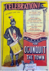
Ogunquit Celebration 1979

Ogunquit separated from Wells in 1980, incorporating as a stand- alone town, and celebrated with a parade through the village. The following decades have shown that Ogunquit continues to be unique among coastal Maine towns with its long stretch of beach forever preserved for the public as well as its rich arts and cultural heritage.

Rebuilding the Village

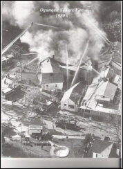
In May 1982 at 2:20 PM, a major fire broke out in the village, leaping from building to building and destroying much of the east side of Route 1. Nine shops, a hotel and a gas station were all badly damaged or destroyed. Residents reacted quickly, removing as much as possible from each building. One eyewitness said, “Finally I Ogunquit Fire 1982 got up and looked for myself and couldn’t believe it. It was like a fog just rolled into town — an evil fog.” Firefighters from Ogunquit and five surrounding towns joined in to control the fire. It was a credit to the community that the Town was back up and running for the summer season.

Population Growth and Preservation Efforts
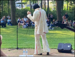
The early years of the 21st century saw substantial residential growth in Ogunquit, as many seasonal residents converted their homes into permanent residences and sought to take advantage of community amenities year-round. This resulted in a nearly two-fold population increase during the first two decades, from fewer than 900 residents to more than 1,500. In April 2015, another fire erupted at the Blue Water Inn near the Main Beach, totally destroying the restaurant and inn. Both were later replaced by a modern restaurant and hotel space.
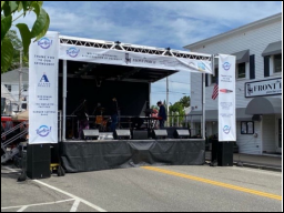
In 2020, the Covid-19 pandemic created a major disruption to life and business in Ogunquit. The restrictions forced the Town to postpone a planned celebration for the 40th anniversary of its incorporation. The celebration finally took place on June 10, 2022, with the Spring BonAire event, featuring numerous concerts, children’s events, a craft fair, an art walk, sand drawing on the beach, a live lobster sale off the boats, and fireworks at the Main Beach.

Continuing Preservation

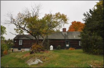
In its evolution from a fishing village surrounded by farms to a seashore destination community, Ogunquit has seen buildings both simple and stately rise along its roads. Because Ogunquit was never a busy port like York or Portsmouth, its early buildings tended to be simple, like the Goodale-Stevens Farm circa 1720. Later buildings, as Ogunquit attracted more residents and grew more prosperous, were more elaborate and reflected building trends of the time. As happened in many other Maine communities, Ogunquit lost older houses and buildings, particularly along Route 1 and Shore Road, as commercial ventures moved in and even if not demolished, some historic buildings were altered as they were repurposed for commercial uses.
Ogunquit has many other buildings identified in the previous Comprehensive Plan as either eligible for listing on the National Register or potentially eligible for listing. The Ogunquit Historic Preservation Commission (OHPC) corroborated that these properties still exist, are of interest and added a property to the list. To assist with preservation efforts, the Maine Historic Preservation Commission (MHPC) awards grants for education, planning, survey, and National Register application work. In 2017, approximately $50,000 was available. Each grant requires a 50% match. These grants can be utilized to collect and analyze information on the location and significance of historic properties, produce National Register nominations, educate the public about the benefits of historic preservation, or assist local governments with preservation planning. Eligible applicants include state agencies, municipal governments, educational institutions, and private non-profit institutions.
Design Review requires that the Planning Board review pre- December 31, 1930 property applications.
Ogunquit’s municipal codes include its Title XI Historic Preservation ordinance, which provides a legal framework by which the Town can protect and preserve its historic, architectural, and cultural heritage.
Ogunquit’s municipal codes include its Title XI Historic Preservation ordinance, which provides a legal framework by which the Town can, through the OHPC, protect and preserve its historic, architectural, and cultural heritage. Ogunquit also adopted Zoning Ordinance Article 11 Design Review, which requires Planning Board review of pre-December 31, 1930, property applications. Proposals for changes on newer projects, which may affect pre-1930 properties within the District, are also subject to review. This Ordinance states that the OHPC must also review and comment on the application under the Historic Preservation Ordinance and Design Guidelines. Having such regulations demonstrates that Ogunquit is serious about historic preservation.
The Town has experienced some difficulties with implementing the existing Ordinances. Two of these difficulties are: there is no defined local historic district or districts which share certain characteristics as are more typically encountered when a community has historic preservation regulations; and the regulations as written do not provide standards by which to specifically determine when a property slated for change will adversely affect a property or a neighborhood deemed historically significant. In determining how best to solve these ordinance issues, so that both the Town and the Design Review applicants get the best possible outcomes, the Town may want to consider providing funding to the OHPC so that it can begin to administer the Title XI ordinance, obtain legal advice on historic preservation law, and apply for the MHPC’s grant to assist Ogunquit with preservation planning. The grant could also assist the Town with identifying and documenting historically significant buildings.

Historic Resources

This section describes historic districts, buildings, structures and objects located above the ground. Ogunquit recognizes and appreciates its historic buildings and landmarks. In 2000, the Town adopted the Title XI Historic Preservation Ordinance which authorizes the OHPC’s duties, functions, and powers. The Title XI Ordinance provides for procedures by which the OHPC may review an application for a Certificate of Appropriateness or a Certificate of Demolition on a historic building or site and by which the OHPC may designate a building or site as historically significant. At the same time as the Ordinance was adopted, the Town approved designating the Perkins Cove Bridge as a historic structure through Town Meeting and later, residents voted to designate the Winn House, the Dolphin Post, and seven other buildings as historic structures.
In 2000, the Town adopted the Title XI Historic Preservation Ordinance which authorizes the OHPC’s duties, functions, and powers.
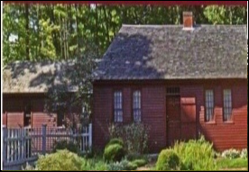
In addition to the historical designation process that the Town has put into place through its Ordinance, there is also the National Register of Historic Places. This federal listing, which is administered by the National Park Service, is part of a national program to coordinate and support public and private efforts to identify, evaluate and protect historic or archeological resources. The Register does not, however, provide any protection Goodale-Stevens Farm against demolition or alteration unless the structure in question has received federal funding for its restoration – only local designation can truly protect structures from demolition. Such funding is typically only available for commercial structures.

Ogunquit has eight sites listed in the National Register. They are:

  • Goodale-Stevens Farm – circa 1720, locatedon the east side of North Village Road, just south of the Ogunquit 
  • Goodale-Bourne Farm – circa 1740, locatedon the west side of North Village 


  • Winn House – circa 1780, moved from itsformer location on Route 1 where the Gorges Grant Hotel is now to Obed’s Lane on

Winn House


the historic Jacobs lot in the 1980s. The building currently houses the Ogunquit Heritage Museum and its collection of historical artifacts, documents, and books. As noted earlier, it was also recognized by the Ogunquit voters as historic.


  • Charles Perkins Homestead – circa mid to late1700s, located on the west side of Route 1 at Scotch Hill, probably built by David  According to the OHPC, the Charles Perkins Homestead was 
  • demolished some years ago. Across the street, the David Maxwell homestead still exists as the store now known as Panache.


Ogunquit Memorial Library


  • OgunquitPlayhouse, circa 1937, located on Route 1, was added to the Register in 1995 and elevated 
  • in 2015 to a “National Level of Significance” 
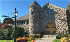
  • Ogunquit Memorial Library – circa 1897, located on thenorth side of Shore Road, was built by Nannie Conarroe in memory of her husband, George, along with a trust fund to maintain 
  • Colonial Inn – circa 1890, located on the east side of Shore Entered into the National Register on July 30th, 2012 under Entertainment and Recreation Criterion C. Architecture. This turn of the century hotel 
  • offers an important visual look back to summer hotels that provided escape from the unhealthy city heat from 1890 through 1960.
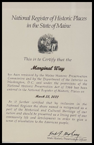
The Marginal Way was added to the Register in 2022. More information is available in the Appendices
The OHPC has prepared the Ogunquit Historic Preservation Register, which includes:

  • PerkinsCove Bridge, the iconic footbridge spanning the
  • WinnHouse, late 1700’s, as noted
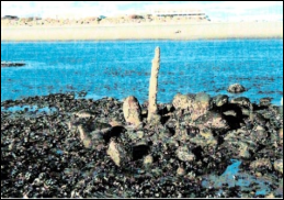
  • TheDolphin Post, 1700s, sits on the curve of the Ogunquit River and is visible only at low  It was used to help schooners move safely to Ogunquit’s busy wharfs.

Perkins Cove Bridge

  • CiampaBoarding House, prior to 1885, built for summer boarders in the Queen Anne
  • LocustGrove Cemetery,
  • OgunquitMemorial Library, 1897, as noted
  • MileMarker, c 1769, placed on Post Road noting the distance of 89 miles to
  • OgunquitPlayhouse,
  • TheMarginal
  • WoodburyStudio, 1898, the first school of the Ogunquit Art Colony, owned by Charles  Woodbury.

Ogunquit has 22 historic cemeteries, most of which are privately owned, but maintains Riverside, with plots dating back to the mid 18th Century; Locust Grove, also dating back to the 1750s; and the small Old Burial Ground, dating to the 1850s.
Archeological Resources in Ogunquit

Beyond buildings, structures, or districts there are archeological sites, which are sites of historic significance located below grade (underground). A vessel, buried in sand on the Ogunquit River just north of the Beach Street Bridge, is believed to be the Enterprise, a 55-foot schooner thought to have been abandoned in the 1880s. Four precontact archeological sites along the banks of the Ogunquit River have been identified by the MHPC as having possible archeological significance. MHPC has drafted a map with the approximate locations. One may contain artifacts from the Ceramic Period, which was from 1000 BC to about 1500 AD. Survey work is required to be certain. Per MHPC regulations, any area within 250 feet of the Ogunquit River and the entire oceanfront can contain archeological sites. MHPC recommends that field checks be done in these areas prior to any ground disturbance or construction activity.
A shipwreck, buried in sand on the river just north of the Beach Street Bridge, is believed to be the Enterprise, a 55-foot schooner thought to have been abandoned in the 1880s.

Threats to Historic and Archaeological Resources

As residential construction has increased within Ogunquit, this has frequently involved the demolition of older homes to construct new homes. The cost of maintaining older homes and buildings can result in deferred care that negatively impacts building integrity, as has been the case with the Ogunquit Village School. The town monitors development and construction to protect historic sites, but there is concern among residents that the historic atmosphere and charm of the town could be at risk.

There are many risks facing the town’s historical sites. The Ogunquit Village School is one example. Other historic buildings not listed as such under the guidelines of Ogunquit Municipal Ordinance 97 Article III §97-9, have been demolished; Design Review can require modifications to the architectural design, but cannot always protect the structure itself from demolition. The Marginal Way has repeatedly suffered damage from storms in the past, and sea level rise presents further risks.

The strategies from the 2004 Plan have been adopted, but time has shown that more can be done. The OHPC has developed a list of older buildings in town, but few have been locally designated as historic under the municipal Ordinance. Additionally, the Ogunquit Zoning Ordinance was revised to require reconnaissance surveys of potential archeological sites, but its effectiveness is unknown. The Ordinance also requires analysis of development applications for resources on or near the site, and while it has been effective, there is room for improvement.
The strategies from the 2004 Plan have been adopted, but time has shown that more can be done.

Goals, Policies and Strategies

Goal

  • To protect, preserve and inventory the historic structures, sites, significant archeologicalresources and character in Ogunquit and ensure changes are carried out to minimize adverse impacts to such

Policies:

  • Tocontinue to protect the significant historic and archaeological resources in the
  • Tocommunicate Ogunquit’s rich history with residents and
  • Toimprove documentation of Ogunquit’s historical resources and risks to those

Strategies:

  • Priority: 1-5 with 1 being the highest priority.
Description Priority Responsibility
Complete a historic resources inventory survey to add to the Town Ordinance (Designated Historic Sites, Landmarks, and Structures) for future protection, including those outside the district requiring design review. 1 OHPC
Ensure that new and modernized municipal structures maintain the charm of Ogunquit’s history. 2 Planning Board
Analyze and make recommendations on tightening Historic building restrictions. 3 Planning Board
Preserve and protect the Marginal Way coastline, with its unique geological features and its historic role in Native American life. 4 Marginal Way Committee
Analyze and make recommendations enhancing OHPC authority including the creation of historic preservation districts. 5 Select Board
Amend the Ogunquit Zoning Ordinance to require that all new construction incorporate maps and information provided by the Maine Historic Preservation Commission into the application process.   Planning Board
Develop accessible resources for maintaining and communicating Ogunquit’s history including a historical and architectural digital archive.   OHPC
Conduct a public ceremony to unveil the National Register of Historic Places plaque for the Marginal Way.   Marginal Way Committee
Celebrate the 100th anniversary of the Marginal Way in 2025.   Select Board
Analyze and make recommendations for incentivizing the preservation of historic homes.   OHPC
Analyze and make recommendations on whether the 1930 date for design review should be updated to older than 50 years in the OZO.   CEO
Amend OZO to require protection of known prehistoric and historic archeological sites during any construction activities.   Planning Board
Work with the Heritage Museum, Wells-Ogunquit Historical Society and the Maine Historic Preservation Commission to assess the need for and, if necessary, develop a plan for a comprehensive community survey of the Town’s archaeological resources.   OHPC
Update Municipal Ordinance §97-11 A to reflect additions approved by voters on 04/07/2007   Town Manager
Add a Demolition Delay provision to the OZO, per Maine Historic Preservation Commission recommendation   Planning Board