Chapter 10: Transportation

Introduction: Ogunquit’s Roadway Network
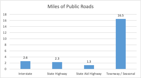
The Town of Ogunquit’s roadway system ranges from rural country roads, to the U.S. Route 1 corridor, to the six-lane Maine Turnpike (I-95), which serves as Maine’s gateway from the Boston metropolitan area and the eastern United States. Both the Maine Turnpike and U.S. Route 1 are heavily traveled, especially during the ten-week summer tourist season from late June through Labor Day.
A total of 22.7 miles of public roads lie within Ogunquit. According to data from MaineDOT, there are 2.6 miles of Interstate Highway, 2.3 miles of State Highway, 1.3 miles of State Aid Highway, and 16.5 miles of local roads. The meaning of each of these road designations will be explained within this chapter, along with data on road condition, bridges, a of road users (also known as “modal split”), the regulatory framework for review of transportation impacts associated with land development in the Town, and transportation-related Town policies.
Ogunquit’s transportation network consists of approximately 22.7 miles of public roadways.

Roadway Network and Classifications

Ogunquit’s transportation network consists of approximately 22.7 miles of public roadways, including U.S. Route 1, the community’s primary thoroughfare. The majority of Ogunquit’s roads are local roads, providing access to State highways and service roads for adjacent property owners that accommodate little or no through traffic.

State Classification

In the early 1980s, the Maine Legislature authorized and directed MaineDOT to classify all public roads, which are referred to as highways by state and federal terminology,

 throughout the State. The basis of this classification system was that roads serving primarily regional or statewide needs should be the State’s responsibility and roads serving primarily local needs should be municipal responsibility.

The State’s classification system is set out below:

  • State Highways form a system of connected routes throughout the state that primarilyserve intra- and interstate  The State is responsible for all construction/reconstruction and maintenance on the 2.3 miles of arterial highway (Route 1) in Ogunquit.
  • StateAid Highways connect local roads to the State Highway System and generally serve intracounty rather than intrastate traffic  State aid roads are usually 
  • maintained by MaineDOT in the summer and by the municipalities in the winter pursuant to State Law 23 MRSA 1003. The State Aid Highway category generally corresponds with the federal ‘collector’ classification. Shore Road is the only State Aid Highway and is approximately 1.3 miles long.
  • Townways are all other highways not included in the State Highway or State Aid Highway classifications maintained by municipalities or counties. These roads are classified as federal ‘local’ roads. There are approximately 4 miles of local roads in Ogunquit.

Federal Functional Classification

In addition to the State classification system, there is the Federal Functional Classification system. The federal system complements the State’s system and is based on the type of service the roadway is intended to provide. The federal classifications relate to traffic capacity and volume attributed to the roads and are divided into rural and urban systems. While State classification designates maintenance jurisdiction, federal functional classification creates a hierarchy of roads and determines which roads are eligible for federal highway funds. Functional classifications are reviewed after each census and updates are made to ensure classifications are in line with road functions.

There are three functional classes represented in Ogunquit as described below:

  • MinorArterials are roads that place a greater emphasis on land access than the principal arterial and therefore offer a lower level of mobility. They serve as links between larger and smaller towns or as connections between collectors and the primary arterials. In Ogunquit, Route 1 is the only Minor Arterial and therefore eligible for federal aid.
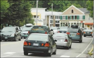
  • Major Collectors differ from arterial roadways due to size and general service area.Collectors serve traffic in a specific area, whereas arterials generally serve traffic moving through an  Average trip lengths

on collectors are shorter than trips on arterials. Collectors gather traffic from local roads and streets and distribute it to the arterial. Major collectors are eligible for federal aid and include Shore Road in Ogunquit.

  • Local Roads primarily provide accessto residential  They are designed for low-speed travel and to carry low


volumes of traffic relatively short distances and are generally not eligible

Example of Minor Arterial Road


for federal aid funding for improvements or maintenance.

Traffic Volumes

MaineDOT monitors 71 permanent traffic recorder sites across the state, monitoring traffic volumes 365 days per year on an hourly basis. Maine DOT also monitors thousands of short duration count locations throughout Maine, including 35 locations in Ogunquit, typically collected on a three-year rotating schedule. The data from the short duration counts are adjusted using the States’s permanent counter data to develop Average Annual Daily Traffic (AADT) volumes. The data below displays AADT data from 9 locations in Ogunquit, not including Route
        2007-2013 2013-2019
Traffic Counts Locations: 2007, 2013, 2019 2007 2013 2019 Change Percent Change Percent
  Berwick Road west of US 1   2,250   1,880   2,290   -370 – 16.44%   410   21.80%
Berwick Road at Maine Turnpike / York Townline   1,010   810   1,080   -200   19.80%   270   33.33%
  Agamenticus Road at York Townline   920   650   800   -270 – 29.35%   150   23.08%
Shore Road at York Townline 2,310 1,700 1,900 -610 26.41% 200 11.76%
Shore Road southeast of Bourne Lane 5,600 4,840 4,910 -760 13.57% 70 1.45%
  Shore Road northwest of Obeds Lane   6,420   5,110   –   -1,310 – 20.40%   –   –
Beach Street east of River Road @ Bridge 3492 2,680 2,620 -60 -2.24%
  Perkins Cove Road southeast of Shore Road   4,260   2,630   2,650   -1,630 – 38.26%   20   0.76%
  Captain Thomas Road west of Route US 1   1,090   890   1070   -200 – 18.35%   180   20.22%

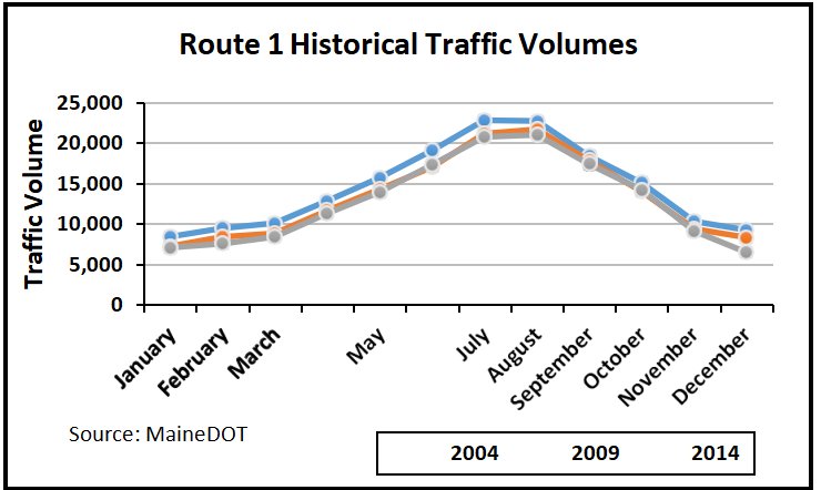
Until 2014, MaineDOT was collecting traffic data on U.S. Route 1 with a permanent traffic recorder, located just north of the intersection with Captain Thomas Road. Not surprisingly, the months of July and

August   experienced   the          

most traffic along U.S. 1 in Ogunquit. Between 2004- 2009, the traffic volume decreased, with all

months experiencing at least a 2.8% reduction. Between 2009-2014, the traffic volume still decreased, but less significantly. These decreases are most likely a result of the economic downturn that began in 2008.

Motorists using Route 1 as an alternative to I-95 contribute to the congestion in the downtown area during the peak summer months. Despite the presence of many public and private beach parking lots, they fill to capacity quickly on summer days, causing traffic to back up on connecting roadways. In 2018 a permanent traffic counter was installed along Route 1 at the Wells town line. MaineDOT has published data for 2018, 2019, and 2021, which is displayed below. 2020 data was omitted due to the reduction of traffic as a result of the stay-at-home orders associated with the Covid-19 pandemic. Monitoring this location, and the associated detailed data, into the future can help with determining traffic growth rates and seasonal fluctuations.
The months of July and August experienced the most traffic along U.S. 1.
US Route 1 (Bridge over Ogunquit River) at Wells town line
Year 2018 2019 2020 2021
AADT 12,460 13,140 NA 13,530
Source: MaineDOT

Pavement Conditions

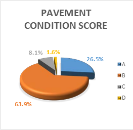
As part of MaineDOT’s asset management methodology, pavement condition data is collected every two years on all State Highways and State Aid Highways. MaineDOT uses the Pavement Condition Rating (PCR), a 0-5 scale that is composed of International Roughness Index, rutting, and two basic types of cracking. The A-F scale (A being great condition) varies by Highway Corridor Priority.
As of 2022, less than 10% of Ogunquit’s State maintained roads fall into the C and D categories, with no segments of road falling into the F category. As seen in the following chart, over 90% of Town roads are in good and great condition (A or B) which is well above the statewide percentage. Although this data changes as sections of roads deteriorate and receive new pavement, it gives a general idea of the condition of State roads in Ogunquit and provides a benchmark for customer service level.
Over 90% of town roads are in good and great condition.
Because Ogunquit has only 16.5 miles of local roads, the Town does not use a road maintenance database system. The DPW evaluates the road conditions annually and schedules road and sidewalk repairs during the budget cycle, financed as capital projects. For example, the 2024 budget includes $50,000 for repaving three roads and $85,000 for improving one sidewalk and adding another. Road conditions in Ogunquit vary depending on the original construction, recent maintenance and preservation, traffic volumes and type, and geographical conditions which include stormwater drainage. Ogunquit street design and construction standards allow the Town to control how new roads are constructed. Maine law allows towns to post roads to limit heavy truck traffic, which is known to cause significant damage to a road. The purpose of this restriction typically is to prevent as much damage as possible to the roadways while they are thawing and in a vulnerable state. As the season shifts toward spring, and the temperatures rise, the melting snow and ice saturates the ground under the roads, and this weakens the base that the asphalt is laid upon. This weakened base cannot support the stress of heavy loads and can result in costly and avoidable road damage.

Crash History and Trends

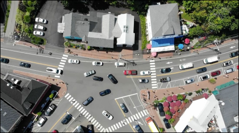
MaineDOT has a system that it uses to rate crash locations throughout the state called High Crash Locations (HCLs). HCLs are given greater attention for funding projects by MaineDOT for their safety programs. In order to qualify, HCLs must be at locations that have had at least eight crashes in a three-year period. It also must exceed the Critical Rate Factor (CRF) of 1 or greater. A CRF is the average expected rate of crashes for a location (based on statewide data of similar crashes). HCLs are updated annually using the previous three years of crash data. In Ogunquit, there are several road segments and intersections along Route 1 that have historically been identified as HCLs. The most common HCL in Ogunquit has been the intersection of Main Street, Beach Street and Shore Road.
The most common HCL in Ogunquit has been the intersection of Main Street, Beach Street and Shore Road.
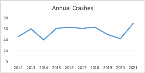
The Bicycle-Pedestrian Committee is currently working with the Maine DOT Village Partnership Initiative to investigate what actions could be taken to improve the safety of this intersection for drivers and alternative road users. Segments of Route 1 from School Street to Shore Road and from Glen Avenue to Grasshopper Lane, have been considered HCLs in the past. Overall, the total number crashes in Ogunquit trended down in 2019 and 2020 before hitting a record high of 70 crashes in 2021. Safety improvement projects along with reduced traffic and tourism as a result of the Covid-19 pandemic may have contributed to the low in 2020 while the high crash number in 2021 may reflect an increase in visitors returning in 2021. The table below indicates that there were 556 crashes in Ogunquit between 2012 and 2021.

Bridges

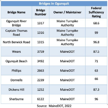
MaineDOT defines bridges as structures designed to convey traffic over a body of water or other obstruction with a span length equal to or greater than twenty feet. There are nine bridges in Ogunquit. Three of them are owned and maintained by the Maine Turnpike Authority and the remaining six bridges are owned and maintained by MaineDOT.
Bridge condition is monitored every two years and given a Federal Sufficiency Rating (FSR). Each FSR has a numeric indicator of the overall value of the sufficiency of the bridge. A rating between 0-100 is given to each bridge (0 indicates the worst and 100 indicates the best). This rating gives an overall value of the sufficiency of the bridge. Since functional obsolescence (too narrow or low weight capacity) may account for a large portion of the rating, one should not assume that a low sufficiency rating means the bridge could fail.

Ogunquit’s Transportation Users

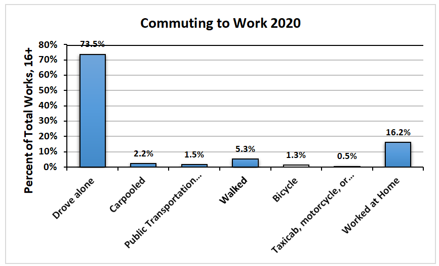
Similar to most Maine communities, the automobile supersedes all other modes as the predominant mode of transportation for Ogunquit residents and workers. Nearly 75% of all workers drove alone, while just 2% carpooled to get to work. While the car is dominant because of its convenience, it is notable that approximately 5% of all workers walked to work. This is a high percentage compared to other southern Maine communities and is reflective of the walkability that exists in Ogunquit. Bicycling does not appear statistically significant but that may be because workers who bicycle are not residents of Ogunquit or work seasonally.
Nearly 75% of all commuters drive alone.
It is also significant that around 16.2% of all workers did so from home. As the world becomes more and more interconnected via the internet, this could also have implications for the Town’s transportation system as fewer residents need to leave their homes to work and contribute to traffic congestion.
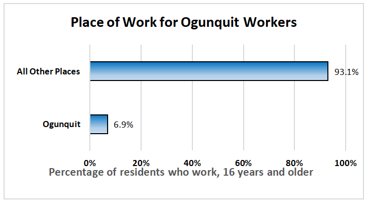
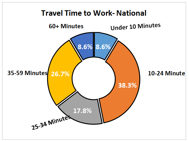
A consistent issue throughout Maine and the rest of the country is that traffic tends to build up during the “commute hours,” or the time(s) of day when people are driving to and from work; in transportation parlance, this is known as “peak hour” congestion. Nearly 23% of workers in Ogunquit travel less than 10 minutes to work. Around 30% of workers commute between 10-24 minutes. Nearly 21% of workers commute an hour or more. Only 6.9 percent of the people who are employed and live in Ogunquit, work in Ogunquit, while the remaining 93.1% of Ogunquit’s residents who work commute elsewhere to work. Town residents have an average commute time of 29.9 minutes, per Census ACS data.

Alternatives to single occupancy vehicles

While the private automobile continues to be the primary means of transportation in Ogunquit, there are several additional motorized and nonmotorized modes of transportation, including bicycling, walking, the Ogunquit Trolley, and the Amtrak Downeaster passenger rail service. In recent years there has been a rise of personal and commercial “Low Speed Vehicle” registrations, these are used by residents and businesses for transporting people, typically in golf cart style vehicles.

Bicycling and Walking

Active modes of transportation such as bicycling and walking help to reduce congestion and vehicular traffic, promote healthy communities, and encourage economic vitality. Because Ogunquit is a destination community in the warmer months, its traffic flow differs from that of the average Maine community. The vehicular traffic flows denser and constant during the tourist season and ebbs considerably in the months of January – March. On any given summer day, groups of pedestrians stream steadily along Route 1 sidewalks and down side streets towards the beach carrying beach chairs and towels. Ogunquit’s seasonal workers often do not have access to cars. Biking and walking are important modes of travel for them as well as for residents who prefer not to drive. The completion of the MaineDOT Route 1 reconstruction resulted in better and more attractive sidewalks and pedestrian crossings as well as an improved main thoroughfare. The reconstruction project added a separate marked bike lane for the two-mile length of Route 1 between the York and Wells town lines, except for the Ogunquit village area.
Bicycling and walking help to reduce traffic congestion and promote healthy communities.
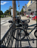
“Share the Road”, “Bicycles may use full lane” and Bike Lane signage was added. The Town recently added sidewalks on Agamenticus Road and is proposing to extend the sidewalk on Berwick Road and add sidewalks on Obeds Lane. The Bicycle-Pedestrian Committee in Ogunquit advocates for and helps to raise awareness of bicyclists and pedestrians in the community. The Committee strives to make walking and biking in town safe and inviting. The Committee has close ties to the Bicycle Coalition of Maine; members regularly attend the annual National Bike Summit. At the Committee’s recommendation, the Town has installed bike racks throughout town. Use and location are reviewed annually. In 2024, the committee will create an information card and a mobile app showing where these bike racks are. The Committee’s goal is to have Ogunquit named a Bicycle Friendly Community by The League of American Bicyclists. The Committee has also been investigating different ways to better regulate micromobility vehicles, which are becoming more common.

Ogunquit Trolley

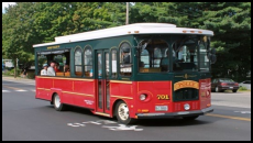
The Ogunquit Trolley is a privately owned and operated public transportation service. Ogunquit has worked diligently to keep the trolley a viable and affordable option for visitors and residents. The trolley services Ogunquit from mid-June through Columbus Day weekend.

Amtrak Downeaster at Wells Transportation Center via Shoreline Explorer
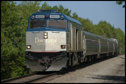
The Amtrak Downeaster is a passenger rail service that runs from Boston, Massachusetts to Brunswick, Maine. The closest station is located at the Wells Transportation Center. Although

there is no public transportation connecting the Amtrak Downeaster to Ogunquit, in previous years, during the summer, the Trolley Service connected with the Shoreline Explorer through to the Wells Transportation Center. The Blue Line Trolley Service will not operate in 2024.

Bus and Other Services

While there are no commercial bus services in Town,C&J Bus runs out of Portsmouth, NH, and residents


Downeaster service to Boston

often use its services for trips to Boston and New York


City, among others. C&J service from NYC to Ogunquit was recently discontinued. Tourist buses bring many visitors to town. York Hospital provides free transport services to several of its area facilities.There are no local airports nor ferry services in Ogunquit. 

There are paid docking berths available in Perkins Cove for private vessels.

Land Use and Transportation Planning Framework

Review of Land Development Applications and Impacts Mitigation

Land use and transportation are deeply intertwined; with few exceptions, in Maine, new development must generally have frontage on a public way, such as a local street or arterial road, and both the type(s) of new uses and intensity of those uses on a parcel of land have implications for the transportation network within the jurisdiction and regionally. New development is often phased over years and the impacts of the final development, as well as the initial phase(s), on the transportation system should always be considered. The magnitude of new development determines the traffic impacts, and potential remedies (also known as mitigation) that the development will require to ensure that traffic flows and safety for all modes remain viable. Depending on existing traffic volumes, distribution patterns, roadway users, safety issues, and road conditions, development can often have significant impacts on the surrounding roadway network. Certain elements of Ogunquit’s land use regulatory regime stem from the outcome of a specific legal action that resulted from a proposed development. In 2006, the Ogunquit Planning Board approved an application for an age-restricted (55+) housing development on 50 acres of land located on Berwick Road. The Planning Board’s approval was appealed by aggrieved parties to the York County Superior Court in a case generally known as Bodack v Ogunquit. This case is important because it has resulted in the requirement for most development in Ogunquit located within one mile of the Berwick Road/Route 1 Intersection that either generates more than 50 new vehicle trips or requires ten or more new parking spaces to provide a Traffic Impact Study and show no new impacts to the level of service (LOS) for the impacted intersections. This sets a very high bar for any new development; many potential development opportunities have not been able to meet this threshold, precluding development that would have otherwise occurred.

Zoning Requirements and Transportation Implications

In Ogunquit, Chapter 225 of the Town Ordinance, Zoning, regulates what can be built, where it can be built, and what standards development must abide by. Subsection 225-8.13 sets forth requirements for traffic impacts and street access control. By requiring transportation impact studies for development that exceeds the thresholds set forth in that subsection,
Ogunquit’s Planning Board can effectively evaluate and mitigate the effects associated with any new development. Through analysis, recommendations for project phasing and developer participation in necessary improvements can be implemented and problems of safety, congestion, and expensive upgrades to roads that predate the automobile can be avoided. Subsection 228.8.10 within the Zoning Code sets out off-street vehicle parking requirements. In the Downtown Business District and Shoreland General Development 1-Ogunquit Beach and Shoreland General Development 2-Perkins Cove nonresidential uses (with the exception of transient accommodations) are exempted from parking requirements. In all other zones, a minimum of one parking space per use is required, with most uses requiring additional spaces using a rubric that scales the parking requirement according to square footage of the use, number of employees, or other metrics. This allows new development to provide off-street vehicle parking in proportion to the type and intensity of the new use(s). The Ordinance does not expressly prohibit dead end roads in subdivisions. Land available for subdivisions is limited, and parcel sizes are relatively small, resulting in dead end or loop roads being the most feasible design for pending and future developments.
Subsection 225-8.13 sets forth requirements for traffic impacts and street access control. By requiring transportation impact studies for development that exceeds the thresholds set forth in that subsection, Ogunquit’s Planning Board can effectively evaluate and mitigate the effects associated with any new development.

Regional Transportation Planning

KACTS, the Kittery Area Comprehensive Transportation System, is the Metropolitan Planning Organization (MPO) designated by the federal and state government to carry out transportation planning in the Maine portion of the Portsmouth and Dover-Rochester, New Hampshire urbanized areas, which includes the municipalities of York, Kittery, Eliot, South Berwick, Berwick, Ogunquit, Wells, Kennebunk, and Kennebunkport. KACTS is housed within the offices of Southern Maine Planning and Development Commission and is responsible for planning and programming federally funded transportation projects within these municipalities. In addition to project-based planning, the MPO is required by federal law to develop a Long-Range Transportation Plan (LRTP) and a Transportation Improvement Plan (TIP) for the region. The TIP is a short-term capital improvement program that considers projected growth in population, employment, and residential and commercial development as the basis for new policies and projects to facilitate all modes of transportation, including roads and highways, rail, public transit, and biking and walking. As of this writing, Ogunquit does not have any projects slated for the 2024-2027 TIP, but this may change as new infrastructure needs are identified.

Complete Streets Policy

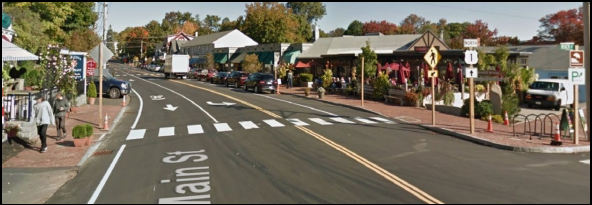
Complete Streets are designed to enable safe access for all users. Complete Streets make it easy to cross the street, walk to shops, and bicycle to work. They also allow trolleys to run on time and make it safe for pedestrians. Cities and towns in Maine, large or small, can begin building a safer and more welcoming street network by adopting a Complete Streets Policy and then ensuring its full implementation. With the reconstruction of Route 1 the Maine DOT provided sidewalks where none previously existed along with numerous crosswalks right through the heavily pedestrian traveled downtown area. As part of the Complete Streets Policy and encouragement of bike use in the community additional bike rack locations should be considered especially as more people are utilizing bikes to get around in the downtown area, avoiding the challenges of finding somewhere to park. By adopting a Complete Streets Policy, communities direct planners, engineers, and other professionals to routinely design and operate the entire right of way to enable safe access for all users, regardless of age, ability, or mode of transportation. This means that every transportation project will make the street network better and safer for drivers, transit users, pedestrians, and bicyclists, making a community a better place to live and visit. In 2017, the Town of Ogunquit developed a Complete Streets Policy with assistance from the SMPDC. Looking north on Route 1

As mentioned earlier, U.S. Route 1 (Main Street) through Ogunquit was recently reconstructed by MaineDOT. The photo above was taken after the project was completed and is a great example of a Complete Street.

Other Existing Facilities

Electric Vehicle Charging Stations

MaineDOT, the Maine Turnpike Authority, Maine Department of Environmental Protection (DEP), as well as other agencies and organizations across Maine have been preparing a number of initiatives relating to the deployment of all electric and plug-in-hybrid vehicles. State and local governments, as well as public utility companies and private businesses have been working to expand the number of electric vehicle charging stations. There are EV charging stations located within the Town:

  • 518Main St: The Dunes on the Waterfront
  • 62Beachmere Place: The Beachmere
  • 74Main St: Meadowmere Resort

These stations are located on private property but are publicly accessible. Multiple EV stations are located in the Obeds Parking Lot adjacent to the Dunaway Center.

Public Parking
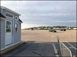
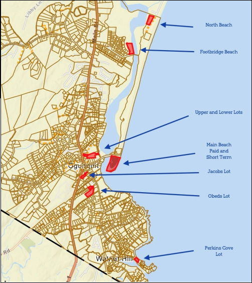
There are six public surface parking lots owned and managed by the Town of Ogunquit. There are four beach lots: Main Beach, Lower Lot, Footbridge and North Beach, and two commercial lots: Perkins Cove and Cottage Street / Obeds. In total these lots have approximately 1,050 parking spaces. From the middle of April to the middle of October each of these lots is a pay to park lot. For the 2014 season approximately 126,000 parking tickets were sold. For the fiscal year that ended June 30, 2015, gross revenue from the sale of parking spaces approximated $1,710,000. In 2022, parking sessions jumped to 227,000 parking tickets sold resulting in a gross revenue of $3,060,000 an increase since 2015 of $1,350,000; this is likely the result of increased tourism following the end of the acute phase of the pandemic. The Town also issues parking passes to employees and residents: In an average year, just over 2,000 passes per season are issued.
During the offseason, there are no parking problems in Ogunquit. During peak seasons, however, Town lots, especially beach lots, are often full before 10:00AM as demand exceeds supply. Late arrivals often line up waiting for spots, increasing already heavy traffic congestion. Recent additions of phone parking applications seem to have increased turnover somewhat, but problems persist.

Conclusion

Ogunquit’s transportation network is generally in good condition. It comes under less pressure in the winter when traffic volume drops. As Ogunquit is likely to remain a highly desirable tourist destination, the need to accommodate vehicles in terms of both road capacity and parking will remain.
The seasonal nature of Ogunquit’s economy sees an increase in people walking, cycling, and using the trolley service in the warmer months. New mobility concepts including e-bikes, scooters, bikeshare, and rideshare, offer alternative modes of travel within the town without additional strain on the street network. These options are more affordable than cars for seasonal workers.

However, allowing these travel modes to mix safely with cars and pedestrians will need creative interventions in allocating street space. Proliferation of electric vehicle charging, aided by efforts from Efficiency Maine and Maine DEP, offer additional opportunities to facilitate low-carbon transport.
Goals, Policies and Strategies

Goal

  • Tomake it safer and easier to move to, from and around Ogunquit for everyone, irrespective of their mode of

Policies:

  • Toprioritize community and regional needs by the safe, efficient, and optimal use of transportation
  • Tomeet the diverse transportation needs of residents and
  • Topromote public health and enhance livability by maximizing the efficiency of the transportation system and minimizing increases in vehicle miles traveled.
  • Tomaximize the efficiency of the State and State-Aid Highway network.
  • Tocreatively increase parking capacity to relieve

Strategies:

  • Priority: 1-5 with 1 being the highest priority.
Description Priority Responsibility
Identify traffic conflict points, such as the location of crosswalks which are causing delays on Route 1, and recommend remedial action. 1 Town Manager
Execute feasibility study for satellite parking lots including a shuttle/trolley to take people to and from town. 2 Visitor Services
Increase public transportation including options to bring key workers to and from Ogunquit, shopping areas and link to the Wells transport hub. 3 Town Manager
Identify and remedy potential accident locations including improving visibility where sightlines are poor. 4 Public Works
Add signs on Route 1 to provide information about the availability of parking spaces in beach lots. 5 Visitor Services
Consider a non-motorized transportation plan for Ogunquit, such as the creation of additional sidewalks.   Bicycle-Pedestrian Committee
Establish a comprehensive rolling program of road maintenance, including identifying more durable road surface materials.   Public Works
Initiate or actively participate in regional and state transportation efforts.   Town Manager
Maintain, enact or amend local ordinances as appropriate to address or avoid conflicts with Maine State law.   CEO
Maintain, enact or amend ordinance standards for subdivisions and for public and private roads as appropriate to foster transportation-efficient growth patterns and provide for future street and transit connections.   Planning Board
Explore options for regional delivery of local services.   Town Treasurer
Maintain, enact, or amend local ordinances as appropriate to address or avoid conflicts with: Policy objectives of the Sensible Transportation Policy Act (23 M.R.S.A. §73); State access management regulations pursuant to 23 M.R.S.A. §704; and State traffic permitting regulations for large developments pursuant to 23 M.R.S.A. §704-A.   Town Manager
Evaluate options for the use of electric bikes in Ogunquit.   Bicycle-Pedestrian Committee
Analyze and make recommendations for remodeling intersections that are not at 90° (e.g. School Street and Rte. 1, Bayview Ave. and Ocean St.) to improve safety for alternate road users.   Public Works
Analyze and make recommendations for adding curbs to protect pedestrians without impacting bicyclists.   Public Works
Explore options for local transportation services.   Visitor Services