Chapter 13: Existing Land Use
Purpose
The major emphasis of the law then, and now, was how to provide for growth in specific areas (Growth Areas) served by public infrastructure (particularly water and sewer), close to municipal services while also maintaining rural areas able to support natural resource-based industries, wildlife habitat, and conservation of natural features.
- Summarizes the breakdown of developed and undeveloped land in terms of estimated acreage and
- Discusses the regulatory regimen that facilitates land development activities within the Town.
- Provides an overview of land use trends, issues, and the general trajectory of how land is likely to be used in the feature.
Background and Land Use History
Existing Land Use Analysis
- Residential(includes single family, two family, and multifamily housing of all types)
- Commercial(includes retail businesses, offices, restaurants, hotels and other lodging and related hospitality uses, commercial parking lots and related uses)
- Industrial(includes areas with light manufacturing uses, and in certain cases, utility- oriented uses if privately owned and operated)
- Vacant(includes both undisturbed land and land that may have previously contained a structure that has since been demolished)
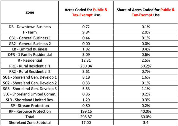
- Public(includes Town-owned land, land owned by other government entities, churches, other non-private entities, or held in trusts)
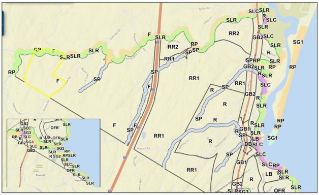
For the purposes of this analysis, these categories are mutually exclusive. In other words, a parcel cannot be coded as both vacant and public/tax exempt; if owned by a church, for example, the parcel would be coded as public/tax exempt, but if privately owned and vacant, it would likely contain a vacant code. As the table on the next page and accompanying land use map show, residential uses constitute the overwhelming majority of
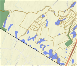
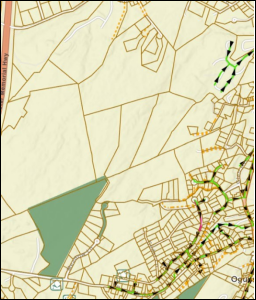
parcels, at 77.4%, as well as the largest single aggregation of acreage by use type, at 44.7% of Town acreage. Commercial land represents just under 10% of parcels in the town and 5% of town acreage. Vacant land constitutes nearly 27% of Town acreage; the hundreds of acres of undeveloped land flanking both sides of Interstate 95 and between Berwick Road to the south and Captain Thomas Road to the north fall into this category, as does much of the public/tax exempt land (22.6% of Town acreage) and some beachfront parcels. At between approximately five and nine acres in size on average, these constitute the largest parcels of land in the Town, while residential and commercial parcels are the smallest, at 0.9 and 0.83 acres, respectively. Regarding parcel sizes, in Maine, beachfront parcel boundaries extend to the low water mark; this means that beachfront parcels may be quite large but have an actual land area that is significantly less.

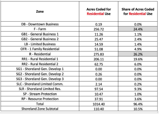
Residential Land Uses
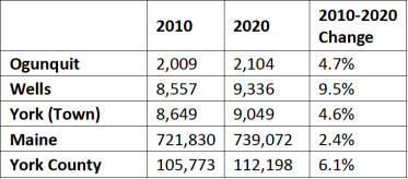
Residential Development Analysis
| Single Family Home Starts 2015-2023 | |
| Year | Number of Starts |
| 2023 | 15 |
| 2022 | 13 |
| 2021 | 17 |
| 2020 | 10 |
| 2019 | 12 |
| 2018 | 7 |
| 2017 | 12 |
| 2016 | 14 |
| 2015 | 14 |
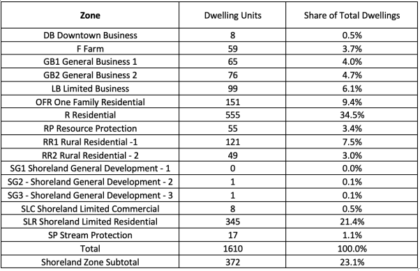
Commercial Land Uses
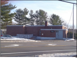
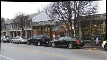
The General Business 1 zone, which contains the core of downtown Ogunquit, holds 9.6% of commercial land uses within just 11.26 acres of land, which is indicative of the small commercial lots that are home to retail storefronts and restaurants within the densest part of the town. The presence of a small (<1%) number of commercial uses in the One Family Residential zone, which prohibits all commercial uses, indicates that pockets of nonconforming commercial uses exist there, as is the case for the Residential zone, which con Existing Industrial Use al uses within 4.1 acres. The commercial uses in these areas likely predate the establishment of Ogunquit’s current zoning ordinance and are grandfathered as a legally non-conforming use.
| Zone | Acres Coded for Commercial Use | Share of Acres for Commercial Use |
| DB – Downtown Business | 5.08 | 3.9% |
| F – Farm | 0.00 | 0.0% |
| GB1 – General Business 1 | 12.60 | 9.6% |
| GB2 – General Business 2 | 40.43 | 30.9% |
| LB – Limited Business | 9.01 | 6.9% |
| OFR – 1 Family Residential | 0.93 | 0.7% |
| R – Residential | 4.14 | 3.2% |
| RR1 – Rural Residential 1 | 0.00 | 0.0% |
| RR2 – Rural Residential 2 | 0.00 | 0.0% |
| SG1 – Shoreland Gen. Develop 1 | 1.90 | 1.5% |
| SG2 – Shoreland Gen. Develop 2 | 2.67 | 2.0% |
| SG3 – Shoreland Gen. Develop 3 | 2.44 | 1.9% |
| SLC – Shoreland Limited Comm. | 32.48 | 24.9% |
| SLR – Shoreland Limited Res. | 18.06 | 13.8% |
| SP – Stream Protection | 0.40 | 0.3% |
| RP – Resource Protection | 0.53 | 0.4% |
| Total | 130.14 | 99.6% |
| Shoreland Zone Subtotal | 57.94 | 44.3% |
Industrial/Manufacturing Land Use
| Zone | Acres Coded for Industrial Use | Share of Acres for Industrial Use |
| DB – Downtown Business | 0.00 | 0.0% |
| F – Farm | 0.00 | 0.0% |
| GB1 – General Business 1 | 0.00 | 0.0% |
| GB2 – General Business 2 | 1.03 | 6.4% |
| LB – Limited Business | 0.00 | 0.0% |
| OFR – 1 Family Residential | 0.00 | 0.0% |
| R – Residential | 0.00 | 0.0% |
| RR1 – Rural Residential 1 | 0.00 | 0.0% |
| RR2 – Rural Residential 2 | 13.90 | 86.4% |
| SG1 – Shoreland Gen. Develop 1 | 0.00 | 0.0% |
| SG2 – Shoreland Gen. Develop 2 | 0.00 | 0.0% |
| SG3 – Shoreland Gen. Develop 3 | 0.00 | 0.0% |
| SLC – Shoreland Limited Comm. | 0.00 | 0.0% |
| SLR – Shoreland Limited Res. | 0.00 | 0.0% |
| SP – Stream Protection | 0.00 | 0.0% |
| RP – Resource Protection | 1.16 | 7.2% |
| Total | 14.92 | 92.8% |
| Shoreland Zone Subtotal | 0.00 | 0.0% |
Vacant Land Use

Public/Tax Exempt Land Use
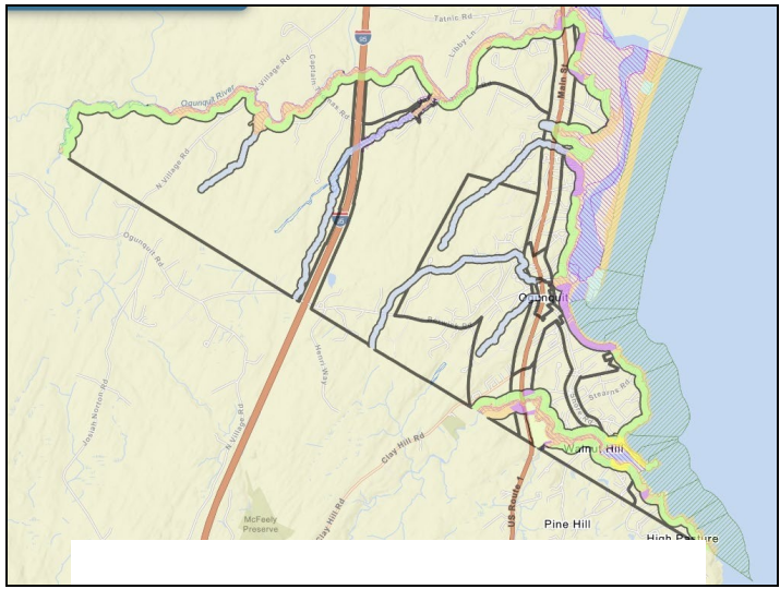
Existing Zoning Districts
Residential Districts:
Business and Commercial Districts:
Downtown Business District (DB) To provide general retail sales, services and business space within the downtown area of the Town of Ogunquit in locations capable of conveniently servicing community-wide and/or regional trade areas and oriented primarily to pedestrian access.
General Business District 1 (GB1) To preserve the architectural character inherent in the district and to provide general retail sales, services and business space within the Town of Ogunquit in locations capable of conveniently servicing community-wide and/or regional trade areas and oriented to automobile and pedestrian access.
General Business District 2 (GB2) To provide general retail sales, services and business space within the Town of Ogunquit in locations capable of conveniently servicing community-wide and/or regional trade areas and oriented primarily to automobile access.
Limited Business District (LB) To preserve the architectural character inherent in the Limited Business District and thus maintain the property’s value.
Shoreland Limited Commercial District (SLC) The Limited Commercial District includes areas of mixed, light commercial and residential uses, exclusive of the Stream Protection District, which should not be developed as intensively as the Shoreland Districts. This district includes areas of two or more contiguous acres in size devoted to a mix of residential and low-intensity business and commercial uses. Industrial use is prohibited.
Shoreland General Development Districts (SG1, SG2, SG3) Ogunquit Beach, Perkins Cove, and Ogunquit Playhouse. The General Development Districts include the following types of existing, intensively developed areas:
- Areas of two or more contiguous acres devoted to commercial or intensive recreationalactivities, or a mix of such activities, including but not limited to the following:
- Areas devoted to lodging, restaurant, retail trade, nonprofit performing artstheaters, and service activities, or other commercial activities; and
- Areasdevoted to intensive recreational development and activities, such as, but not limited to, trails and public
- Areas otherwise discernible as having patterns of intensive commercial or recreational
Other Zoning Districts:
- Innontidal shoreland areas, the land area below the upland edge or high-water line of any freshwater wetland, river, or
- Areaswithin 250 feet, horizontal distance, of the upland edge of freshwater wetlands, salt marshes and salt meadows, and wetlands associated with great ponds and rivers.
- Floodplainsalong rivers and floodplains along artificially formed great ponds along
- Withinthe Shoreland Zones, areas of two or more contiguous acres with sustained slopes of 20% or
- Within the Shoreland Zones, areas of two or more contiguous acres supporting wetlandvegetation and hydric soils, which are not part of a freshwater or coastal wetland as defined, and which are not connected to a water body during the period of normal high
- Landareas along rivers subject to severe bank erosion, undercutting, or riverbed movement, and lands adjacent to tidal waters which are subject to severe erosion or mass movement, such as steep coastal
- Anysignificant wildlife habitat, including significant vernal pools, as defined in the Department of Environmental Protection, Chapter 335, Rules on Significant Wildlife Habitats, whether or not they are included on the Official Zoning map.
Land Use Regulatory Structure
- PlanningBoard: this five-member appointed body is tasked with administering the Town’s zoning ordinance, site plan
- standards, and subdivision Actions carried out by the Planning Board include site plan review,
- Zoning Board of Appeals: this five-memberappointed body hears petitions for variances to the Town’s land use regulatory standards by applicants as well as Administrative
- OgunquitHistoric Preservation
- Conservation Commission: this seven-member board, constituted per Chapter 49 of the Town Code, reviews development applications to ensure that impacts to natural resources and wildlife are minimal, to protect open space, and to implement policy recommendations in the Comprehensive Plan related to the natural
Design Review: Preserving the architectural character and charm of the village of Ogunquit is important to the residents and visitors to the town. Through the Design Review process the Planning Board works to ensure that the renovations to existing structures and new construction are designed in a manner compatible with the character of a given area.
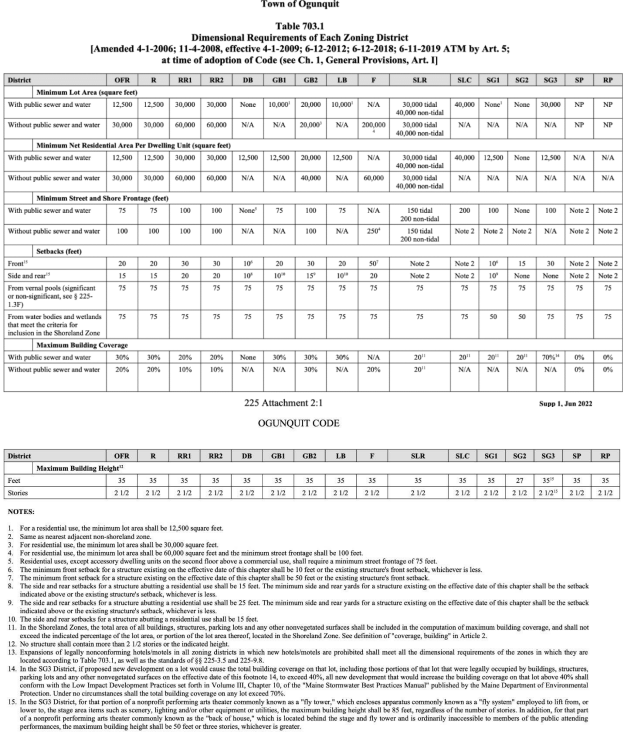
Overview of Land Use Factors Impacting Development
Bodack v Ogunquit case
As described within the Transportation chapter, the 2006 Bodack v Ogunquit case, which requires that any new development within one mile of the Berwick Road/Route 1 intersection show no net impacts on the level of service on roadways, has resulted in the curtailment of development that would have otherwise taken place in the community. As land use and transportation are intimately tied together, and new land uses typically have a baseline increment of new vehicular trip generation associated with them, this threshold likely proves an impossible test for many projects to meet and thus halts most new development in the town within the one-mile intersection radius.
Formula Restaurants
As set forth is Sec. 225-7.13 of the zoning code, Ogunquit does not allow formula restaurants within the community, along with any restaurants with a drive-through window.
Per the Zoning ordinance, the definition of a formula restaurant is as follows:
Formula Restaurant shall mean a restaurant thatstandsaloneas aprincipaluse or with another use as an accessory use, and which prepares food or beveragesonsite for sale to the public, and which is required by contractual or other arrangements to maintain any one or more of the following standardized features, which causes it to be substantially identical to other restaurants, regardless of the ownership or location of those other restaurants: name, menu, food preparation and presentation format; decor, employee uniforms, architectural design, signage; oranyother similar standardized features.
- Thenumber of individuals staying at aproperty at any one
- Thenoise from overnight parties and accumulation of trash occurring on short- term rental
Projected Land Acreage Needed for Development
The Housing inventory chapter includes housing demand projections based on a 12.6% and 25.3% increase in population between 2020 and 2040. Utilizing the 2020 household size of 1.91 persons as the baseline, this analysis yielded an estimate of between 193 and 343 additional housing units needed by 2040. For the purposes of this analysis, these calculations assume that the existing zoning dimensional and use requirements contained in the Ogunquit Zoning Ordinance remain as-is in perpetuity.
As contained within the parcel dataset used to complete the analyses within this chapter, the average parcel size for lots coded as single family within the Assessor’s record is 0.7 acres, 0.33 acres for lots coded as two-family, and 2.16 acres for lots coded as containing three or more units. This works out to a calculated average of 1.42 units per acre for single family residences,
6.06 units per acre for two family residences, and 5.8 units per acre for three or more units. Using the single family average parcel size of 0.7 acres per parcel and assuming household sizes stay the same at 1.91 persons per household, the town would need 135.1 acres of additional developed land area to accommodate the needed housing units using the 12.6% growth scenario, up to as much as 240.1 acres under the higher 25.3% growth scenario. However, when the smaller two-family parcel average size of 0.33 acres is used for this calculation, only
63.69 acres of developed land area are needed under the 12.6% growth scenario, up to 113.19 acres under the 25.3% growth scenario. This reduction demonstrates the ability of denser residential development patterns to help conserve land within the community, reducing impacts on natural areas.