Chapter 5: Marine Resources

Overview

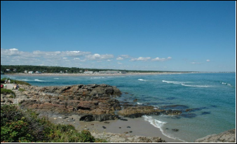
Like other southern Maine coastal communities, Ogunquit’s coastline is predominantly sandy beaches, with some areas of rocky shoreline and a small harbor. The coast serves as the economic backbone of the community and region by drawing in vital tourism dollars and supporting a mix of coastal tourism, recreation, marine-related industry and commercial fishing. Healthy marine resources are critical to the community. Without well-maintained harbors and healthy beaches, commercial and recreational boat traffic cannot navigate waterways and tourists may choose to spend their money elsewhere, impacting not only the region, but the State as a whole with lost critical revenue and business.
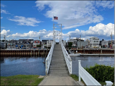
Ogunquit has seen a sustained trend toward recreational use of the ocean and the Ogunquit River, as evidenced by many kayaks, stand-up paddle boards, surfers, canoes and small motorboats. The Footbridge section of Ogunquit Beach has a “put in” for small recreational watercraft. Commercial fishing vessels, charters, and sightseeing boats launch from the Town’s working harbor, Perkins Cove.
Ogunquit has seen a sustained trend toward recreational use of the ocean and the Ogunquit River.

Coastal Water Quality

Protecting Ogunquit’s valuable marine resources requires ongoing attention, continual effort, and adequate resources. The Town has prioritized efforts to protect coastal water quality and address pollutant issues, as outlined in the ‘Water Resources’ chapter of this plan. FBE) continues to work with the Town of Ogunquit to monitor water quality in the Ogunquit River, its estuary and its tributaries. Water quality monitoring takes place each year at consistent sampling locations along the Ogunquit River and smaller tributaries. The monitoring report documents changes in bacteria levels within the estuary to evaluate ongoing remediation efforts and help direct future management actions. Annual monitoring has shown continued high levels of bacteria in some locations within the estuary and along Ogunquit’s beaches, especially after significant rainfall events, a situation Ogunquit, FBE, the State of Maine, and other partners are working hard to address.
The Town has taken steps to address sources of water quality issues through the Ogunquit River Watershed Restoration Project.
FBE continues to work with the Town of Ogunquit to monitor water quality in the Ogunquit River.
In addition to monitoring, the Town has taken steps to address sources of water quality issues through the Ogunquit River Watershed Restoration Project, which is now in its fourth phase. Parts of the project include installing a stormwater retrofit catch basin in the Main Beach parking lot. This key infrastructure upgrade provides for enhanced filtration of runoff from the parking lot surface. The project entails continued engagement of the public with outreach and educational activities to improve awareness around sources of bacteria in the estuary, and what people can do to help.
The Town of Ogunquit works with the Maine Healthy Beaches Program to ensure that Ogunquit’s saltwater beaches remain safe and clean. The program performs standardized monitoring of beach water quality, notifying the public of potential health risks and educating residents and visitors on what they can do to help keep the beaches healthy. Moody/North, Footbridge, Main, Riverside and Little Beach in Ogunquit are monitored Memorial Day through Labor Day for a safety threshold of enterococci in marine waters of no greater than 104 Most Probable Number3 (MPN3) per 100 ml. The sites tested showed that Little Beach exceeded the threshold three times and Riverside Beach exceeded the threshold four times in 2022. Advisories were posted but no beach closures occurred.

Water-Dependent Use

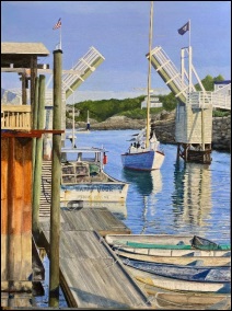
The Town of Ogunquit aims to strike a balance between the needs of working fishermen and recreational and development pressures in its management of coastal areas. Traditional water uses, such as fishing and clamming, continue to thrive, especially in Ogunquit Beach. Perkins Cove, which was once called Fish Cove, fed by the Josias River, was a major source of fishing in the early 1900s, but the Cove was unprotected by a headland or breakwater from Atlantic storms, so fishermen had to protect their boats by hauling them ashore. Resolving to create a safe anchorage, they formed the Fish Cove Harbor Association, and dug a channel across land they purchased to connect Fish Cove with the Josias River. When the trench was complete, erosion helped to widen the passage further. The resulting tidewater basin is called Perkins Cove, spanned by a manually operated draw footbridge.
Today, Perkins Cove is still home of Ogunquit’s active commercial and recreational fishing fleets and lobstermen. The table below shows the active number of commercial and recreational fishing licenses issued by the Maine Department of Marine Resources (DMR) in Ogunquit in 2020.

Commercial Fishing

Licenses (Single & Crew)

Commercial

Lobster/Crab Licenses

Commercial Shellfish Licenses

Total Commercial

and Recreational Fishing Licenses

5 (12 crew)

19

0

82

Commercial and Recreational Fishing Licenses by Town. (Source: Maine Department of Marine Resources, 2020 license data)
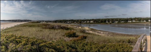
Perkins Cove is at the southern terminus of the Marginal Way, a cliff walk that meanders for 1.25 miles along the coast.
Perkins Cove is also home to numerous restaurants and retail businesses. The Cove remains a thriving destination for artists. Perkins Cove is at the southern terminus of the Marginal Way, a cliff walk that meanders for 1.25 miles along the coast.
The Ogunquit Estuary is a source of clamming. Soft shell clams are a native species that live in mud, sand and gravel intertidal areas in the Ogunquit Estuary. It takes about three to four years for a clam to grow to legal size, which is two inches. Soft shelled clams are regulated by Maine DMR, the Town Shellfish Conservation Commission, and Town Ordinances. Ogunquit requires
recreational licenses which can be obtained through the Town office. The recreational limit is 1 peck, or roughly 12 pounds, per person daily. There is no commercial shell fishing in Ogunquit. DMR monitors the clam flats for the presence of fecal coliform bacteria and closes the flats to harvest when bacteria count rises above a certain level. These are called “water quality closures” which are different from Red Tide closures. The Town Shellfish Conservation Commission and DMR Area Biologist evaluate the status of the shellfish resource and other factors to determine whether the clam flat area should be opened or closed for harvesting. Signage is posted along the estuary when a clam flat is closed.
Threats to Ogunquit’s marine resources include water quality issues as described in the Water Resources chapter, storms, aging infrastructure, sewage, petrochemical and insecticide contamination, and climate change. While sea level rise and coastal flooding threaten both commercial and recreational fishing activity through direct impacts to wharf infrastructure and access to that infrastructure, there are additional climate-related impacts to marine resources. Water quality issues negatively impact coastal wildlife, including commercially harvested Little Beach species. Additionally, climate change causes both warming and acidification of marine waters. The Gulf of Maine is warming faster than 97% of the world’s oceans. The Gulf of Maine Research Institute shares seasonal and annual updates about conditions in the Gulf of Maine, most recently for the fall of 2023. Ocean acidity levels have already risen 30% and will continue rising alongside growing greenhouse gas levels. Ocean acidification has already impacted some shellfish harvesting operations in Maine and will increasingly affect marine organisms that produce calcium carbonate to build shells, such as oysters, scallops, clams, mussels, and sea urchins. These combined climate impacts are already leading to some marine species migrating northward to colder water and disappearing from traditional fishing grounds. This is expected to reduce regional catches and associated revenue for fishermen. Further, Ogunquit’s recreational shell fishing activities could be impacted.
There are several parking and access points in town, including the Perkins Cove public parking area and boat launch, Main Beach, Footbridge Beach and North Beach and their municipal parking lots. A 2022 regional coastal vulnerability assessment by Southern Maine Planning and Development Commission (SMPDC) showed that most of those parking areas are projected to experience flooding from future sea level rise and storms.

Access to coastal and marine resources is vital for Ogunquit’s residents, businesses, and visitors. There are several parking and access points in town, including the Perkins Cove public parking area and boat launch, Main Beach, Footbridge Beach and North Beach and their municipal parking lots. A 2022 regional coastal vulnerability assessment by SMPDC showed that most of those parking areas are projected to experience flooding from future sea level rise and storms. Main Beach parking lot has 400 spaces and Footbridge Beach and North Beach entrance each have 190 spaces. Handicap parking is available in all public parking lots, plus public toilets. Parking is a significant source of Town revenue.
According to Town documents, Perkins Cove has approximately 83 parking spaces consisting of paid parking, 2-hour free parking as posted, and parking
reserved for commercial activities. There are 43 paid parking spaces limited to three hours maximum and about 26 two-hour free spaces beside the footbridge and in the boatyard. It was noted that parking at Perkins Cove does not meet the area’s demand, and there are no options to expand within the Cove. There is adequate parking for commercial fisherman in the Cove – although the demand is growing as charter boat requirements continue to expand – but not members of the public. There are no opportunities for improved access due to limited land. There are public toilets in the Cove.

Harbor, Marinas, and Vessels

Perkins Cove has a public boat ramp for launching and taking out watercraft at the eastern end of the public part of the Cove.
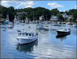
Ogunquit has only one working harbor, Perkins Cove, which is also the sight of the Town’s only municipal wharf. Perkins Cove has a public boat ramp for launching and taking out watercraft at the eastern end of the public part of the Cove.

There are no plans to alter


the ramp. Town Ordinances regulate the marine activities within the harbor to ensure the safety of persons and property, to promote availability and use of public resources and to create a fair and efficient framework for the administration of those resources.

There are 68 moorings in Perkins Cove. The maximum length of watercraft (because of safety) in the Cove is 42 feet, as determined in linear feet based upon a measurement from the rearmost part of the watercraft’s transom to the most forward part of the bow stem,

excluding the bowsprit and/or the pulpit. According Moorings at Perkins Cove


to the Town Harbormaster there are 40 large boat moorings and 28 small boat moorings; 36 of the large boat moorings are commercial and four are non-commercial, 11 of the small boat moorings are commercial and 17 are non-commercial. In 2022, the Town received $27,545 in transient dock revenue. The Town ordinances stipulate the allocation of moorings.
All harbor activities are overseen by the Town Harbormaster, appointed by the Town Manager. The Harbormaster has jurisdiction over all watercraft in the Cove and enforces marine safety rules and regulations based upon the guidelines established by Town Ordinances, the U.S. Coast Guard, and other federal, State or locally recognized authorities. At this time there are no local or regional harbor management plans. There is a yearly evaluation process with the Ogunquit Harbor Committee to identify and plan for the upcoming year including mooring and docking fees, ordinance changes and maintenance of Perkins Cove. As part of the Town budgeting process, the Harbormaster does present a five-year plan for projects such as harbor dredging and repair/replacement of the Perkins Cove bridge. Activities recommended by the Harbormaster include:

  • Revitalizecommercial infrastructure including rebuilding the bridge, harbormaster house, and commercial bait house
  • Rebuildthe commercial pier to add efficient load/unload space for at least two vessels, where currently there is room for only one.
  • Rebuildslipways and winch house and replace all deteriorating old foam style 
On January 19, 2022, the Federal government announced that it allowed more that $3.4 million for surveys and dredging of the Josias River at Perkins Cove by the USACE. It was secured through the bipartisan infrastructure investment and Jobs Acts signed into law in November 2021.
The land around Ogunquit’s working harbor is zoned as Shoreland General Development 2, meaning the area is devoted to commercial and/or intensive recreational activity. Shoreland Zones, including the zone around Perkins Cove, are defined as the land area within 250 feet of the normal high-water line. To protect the marine and water resources, the Shoreland Zone has more restrictive setbacks, lot coverage and density provisions than corresponding zones for residential and commercial uses located more than 250 feet from the high-water line.
Ogunquit has taken proactive steps to protect and manage its vital marine resources. The Town has several municipal Boards charged with supporting protection of resources and assisting the community with maintenance, management, and sustainability. The Perkins Cove Harbor Committee, created in 1992, is responsible for making recommendations regarding certain improvements, regulations, conditions and actions for the betterment and enhancement of Perkins Cove and its mooring holders and general conditions of the Cove.
Ogunquit has taken proactive steps to protect and manage its vital marine resources.

Dredging

Perkins Cove at the mouth of the Josias River, is the primary navigation channel and has a long history of improvement and maintenance dredging dating back to 1951.
Dredging is a key aspect of maintaining harbors and waterways in the region. In Ogunquit, Perkins Cove at the mouth of the Josias River, is the primary navigation channel and has a long history of improvement and maintenance dredging dating back to 1951. The depth required for safe passage within Josias River is -7.0 feet Mean Lower Low Water (MLLW). The primary sediment type within the channel is mud, and dredged materials have historically been barged for offshore disposal.
Perkins Cove in the Josias River is a designated federal navigation project, meaning the U.S. Army Corps of Engineers (USACE) has authority and responsibility over dredging the Cove. However, like many other federal navigation projects in the region that have been permitted and authorized, the frequency of Federal appropriation to support USACE dredging activities does not always align with the local dredging need. The preliminary projected start for the dredging of Perkins Cove (Josias River Federal Navigation Project) is 2024/2025. This project will entail a lengthy process of collecting and testing soil samples, identifying where dredge material in placed, conducting new hydrographic survey of the harbor, development of numerous elements for contract documents, a bidding process, and final award of the contract. As this is an Army Corps project, the Federal Environmental Impact Assessment alone can take up to a year to complete.

Scenic Vistas

Perkins Cove is home to the only remaining wooden, double leaf draw footbridge in the United States. The pedestrian footbridge at the entrance to Perkins Cove is not only a stunning and beautiful symbol of Ogunquit, but a key connection that provides the only southerly access to the numerous small businesses, restaurants and shops located in and adjacent to the Cove.
The Federal Government approved $2,850.000 dollars for the revitalization of the Perkins Cove Pedestrian Footbridge in the 2022 Transportation and Housing Appropriations Bill.
The Federal Government approved $2, 850,000 dollars for the revitalization of the Perkins Cove Pedestrian Footbridge in the 2022 Transportation and Housing Appropriations Bill. For years, the Town has actively evaluated and monitored the structure, making incremental repairs and remaining wary of potential safety hazards arising as the bridge and the piers that support it age. The federal funding will enable the Town to demolish and reconstruct the bridge, the harbormaster building, and the bait storage facility. Additional scenic vistas are cited in the Natural Resources chapter.

Goals, Policies and Strategies

Goal

  • Preserve, protect and promote the Town’s marine resources including shellfish and fisheries habitat, estuaries, shorelands, dunes, coastal waters and water- dependent uses such as Perkins Cove.

Policies:

  • Continue to work with the Ogunquit River Watershed Restoration Project toprotect the coastal water quality and marine
  • Continueto ensure that Perkins Cove retains its function as a commercial
  • To continue to revitalize the infrastructure of the PerkinsCove Harbor (e.g., dredging of the harbor, replace the Perkins Cove Bridge and make it ADA compliant), repair sea wall structures when
  • Ensurean equitable balance between commercial and recreational use of the harbor (moorings included).

Strategies:

  • Priority: 1-5 with 1 being the highest priority.
Description Priority Responsibility
Continue to work with the Army Corps of Engineers, Harbormaster, and Harbor Committee to establish the timeline and cost for surveying and dredging of the Josias River at Perkins Cove. 1 Town Manager
Participate and continue to work with the Ogunquit River Watershed Restoration Project to develop plans and interventions to protect coastal water quality. Report recommendations to Select Board. 2 Conservation Commission
Monitor the health of the clam flats and bacteria levels in collaboration with the Department of Marine Resources and Town Shellfish Commission. Make Town and public aware of high bacterial levels and need to close clam flats if necessary. 3 Shellfish Commission
Implement local harbor management plan including replacing the Perkins Cove Bridge (making it ADA compliant) and repairs to the Harbormaster house. 4 Town Manager
Continue to work with the Department of Marine Resources (DMR) and Shellfish Commission, to identify any pollutants in clam flats and invasive species such as green crabs. Develop strategy to eradicate invasive species. 5 Shellfish Commission
Identify needs for additional recreation and commercial marine access (parking, boat launches, docking space etc.). If there are needs identified, conduct a cost analysis to see if the recommendations are viable.   Public Works
Develop a communications strategy to encourage owners of marina businesses to participate in clean marina programs.   Harbor Committee
Prohibit building future piers along the estuary. Revise and adopt municipal codes accordingly.   Planning Board
Evaluate if there is a need to strengthen lobster/fishing/shellfish industries in Ogunquit and make recommendations to accomplish this if necessary.   Shellfish Commission
Work with local property owners to protect major points of physical and visual access to coastal waters, especially along   Town Manager
public ways. Ensure abutting property owners comply. Develop enforcement mechanisms.    
Prohibit power boats from landing/mooring on the beach or dunes.   Harbormaster